Essay originally published in Bruce Bratton’s weekly online blog BrattonOnline.com.
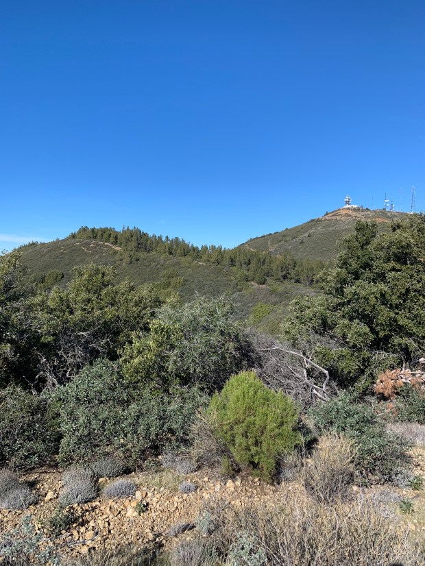
Many of us are drawn to mountain tops if not physically at least visually, some even spiritually. Botanists go to see the unique flora. Some botanists are “peak baggers” along with many others. There is no “bagging” Loma Prieta, but the flora around it is very special. And the peak has been sacred to some but has been defiled by others, now buzzing with communications towers that make you want to stay far away.
At 3,790’ Loma Prieta towers above Santa Cruz, the highest peak of the Santa Cruz Mountains. The mountain is near the Santa Clara/Santa Cruz County Line and looks over the nearby San Andreas Fault. More people know the name of the peak from 1989 Loma Prieta Earthquake – the epicenter was just west of the mountain.
Recharge
It snows up there almost every year and the rain falls in torrents because the highest peaks catch the most rain. There is little soil near Loma Prieta, but lots of well drained rock. There are patches of sandstone surrounded by a massive amount of mudstone. Craggy dark sandstone outcrops accent the slopes near Loma Prieta. Roadcuts reveal fascinating patterns formed by the nearby faulting. The mudstone and sandstone rocks were created by sediment washed into the Pacific from ancient California’s rivers, laid down in layer after layer, with different layers of slightly different colors, textures, and thicknesses. Tectonic movement has pitched those layers this way and that, sometimes in great undulating waves, other times tilted this way and that. The roadcut rock is fascinating mosaic art.
Rain soaks through these fractured stones, bubbling out below to form the headwaters of streams that provide drinking water for hundreds of thousands. Looking out from the mountain, you see the steep and thickly wooded Soquel Creek canyon or turn towards the other side and look down Uvas Creek that leads to the Uvas Reservoir and onto the Pajaro River, or gaze north into streams headed to the Lexington Reservoir.
Views
I try to visit the area’s peaks once a year to get my bearing and appreciate this place. And, I can see most of those peaks from Loma Prieta: Mount Diablo, Mount Hamilton, Fremont Peak, Devil’s Peak, and Ben Lomond Mountain are visible from there. A while back, I would visit Loma Prieta to get a good view of the region’s fireworks on July Fourth. Back then, the shoreline of the Monterey Bay was lit by many displays and there were many displays in towns all the way to San Francisco and beyond. It is a delightful place to see the entire Monterey Bay and a huge expanse of the sparkling Pacific Ocean. But really, I go for the plants.
This Chaparral’s Shrub Diversity
My favorite plants to visit up that way are two subspecies of at type of manzanita that is normally found a long ways north, but which have outlying patches on sandstone near Loma Prieta. The Hoary (A. canescens ssp. canescens)and Sonoma (A. canescens ssp. sonomensis) are beautiful silvery shrubs with smooth red bark so dark it is almost black. I visited last weekend and it was just starting to blossom, some shrubs had pure white and others very pink flowers.
This is a very shrub diverse area. In a short distance, in addition to the above, you can find three other manzanitas: Santa Cruz manzanita (A. andersonii) and brittle leaved manzanita (A. crustacea ssp. crustacea) and Rose’s manzanita (A. crustacea ssp. rosei). And, the ceanthus that normally accompany manzanitas are equally diverse with 5 species also occurring in close proximity to Loma Prieta: warty leaved ceanothus (C. papillosus); blue blossom (C. thrysiflorus var thrysiflous), wavy-leaf ceanothus (C. foliosus var. foliosus), buck brush (C. cuneatus var. cuneatus) and Jim brush (C. oliganthus var. sorediatus). More shrubs still include 3 species of silk tassel – bear brush (G. fremontii), silk tassel (G. eliptica), and ashy silk tassel (G. flavescens), mountain mahogany, pitcher sage, chaparral pea, bush poppy, coffee berry, coyote bush, and on and on. With this menagerie of chaparral shrubs, the scents are awesome as the sun warms the millions of resinous leaves.
…and Tree Diversity
Trees are super diverse up there, too. It is surprising to see a rare local conifer California nutmeg emerging from the chaparral. The canyon live oaks are everywhere in multi-trunked patches resprouting from multiple fires. There is also interior live oak, foothill pine, and knobcone pine. Some trees are odd: the madrones have paler orange bark than normal, the bay trees have more flakey bark, and the tanoaks have longer and or smaller more toothed leaves. The patches of trees are especially thickly festooned with beards of mosses and dense carpets of lichens.
Clearing the Shrubs – the March of Weeds
With the exception of a few patches managed by public parks, most of the area is privately owned, and it shows. A County Planner has told me on many occasions that the County’s policy is to not allow clearing of this rare chaparral type. And yet, you can see the expansive clearing from Highway One. There are immense mansions and squalid trailers, many with massive fire clearance zones. And, there are acres and acres of vineyards and horse corrals as well as sprawling greenhouses.
This network of development and the roads that serve them has badly fragmented this beautiful chaparral, especially in the last 15 years. Human incursions are made evident by aisles and acres of weeds: jubata grass, Scotch and French broom, and acacia are the most evident.
Even with all of the clearing but especially with the influx of flammable weeds along the roads, this area seems likely to burn badly one day.
A History of Fires
Many areas around Loma Prieta have not burned in a long, long time; but there have been recent fires. North and West of Loma Prieta, there are some of the oldest, largest knobcone pines I’ve ever seen, evidence that it has been a long time since fire. South and East of Loma Prieta, are miles of skeletons of trees and shrubs that belie more recent fires. The 2008 Summit Fire (4,200 acres), the 2009 Loma Fire (435 acres), and then the 2016 Loma Fire (4,470 acres) all have scorched areas around Loma Prieta, and all were human caused.
How to Visit
You can visit patches of this unique chaparral in a few parks. Some of this type of chaparral is at Mount Madonna County Park. The more shrub-diverse type is found in the Sierra Azul Preserve managed by the Midpeninsula Regional Open Space District at Mount Umunhum, the next peak north of, and not far from, Loma Prieta. The top of Santa Clara County Park’s Uvas Canyon County Park touches the shoulder of Loma Prieta south of the peak. This type of chaparral gets less interestingly diverse but still remains expansive in the upper areas of Nisene Marks State Park, say along the top of Aptos Fire Road.
