Santa Cruz

Contrasting Two Biodiversity Hot Spots

When I can muster it, I travel to the American tropics to experience an even greater degree of species diversity than California. I’d like to share some of what I noticed in the contrasts between the people and places I experienced this December in Ecuador, perhaps the most species rich place on Planet Earth.

A indigenous guided Amazonian river tour in Ecuador, one of hundreds available

Oh, the Riches

One of the most interesting conversations I had while traveling in Ecuador was during the taxi ride back to the airport as I was departing for California. I mentioned to the taxi driver some of the things I’d noticed in Ecuador that contrasted with California. For instance, the roadways were clean – no litter! Also, I hadn’t seen any homelessness during my travels, though I frequented areas where entire people had no obvious means of employment. Everyone I encountered during my 3-week stay had been more than polite – outgoingly kind more like it. And, those with whom I interacted seemed to appreciate and even understand a lot about the biological richness of their country. I told the taxi driver that these things were surprising to me as Ecuador was supposed to be such a poor country. He shook his head and corrected me – Ecuador is a rich country, quoting Friedrich Wilhelm Heinrich Alexander von Humboldt, “Ecuadorians are rare and unique beings: they sleep peacefully in the midst of crisp volcanoes, live poor in the midst of incomparable riches and rejoice with sad music.” He then asked me if the United States was also a rich country, and how well did the people of the USA sleep? I didn’t know quite how to answer. (It turns out that one-in-five US citizens take sleep medication regularly).

Tourism Economy

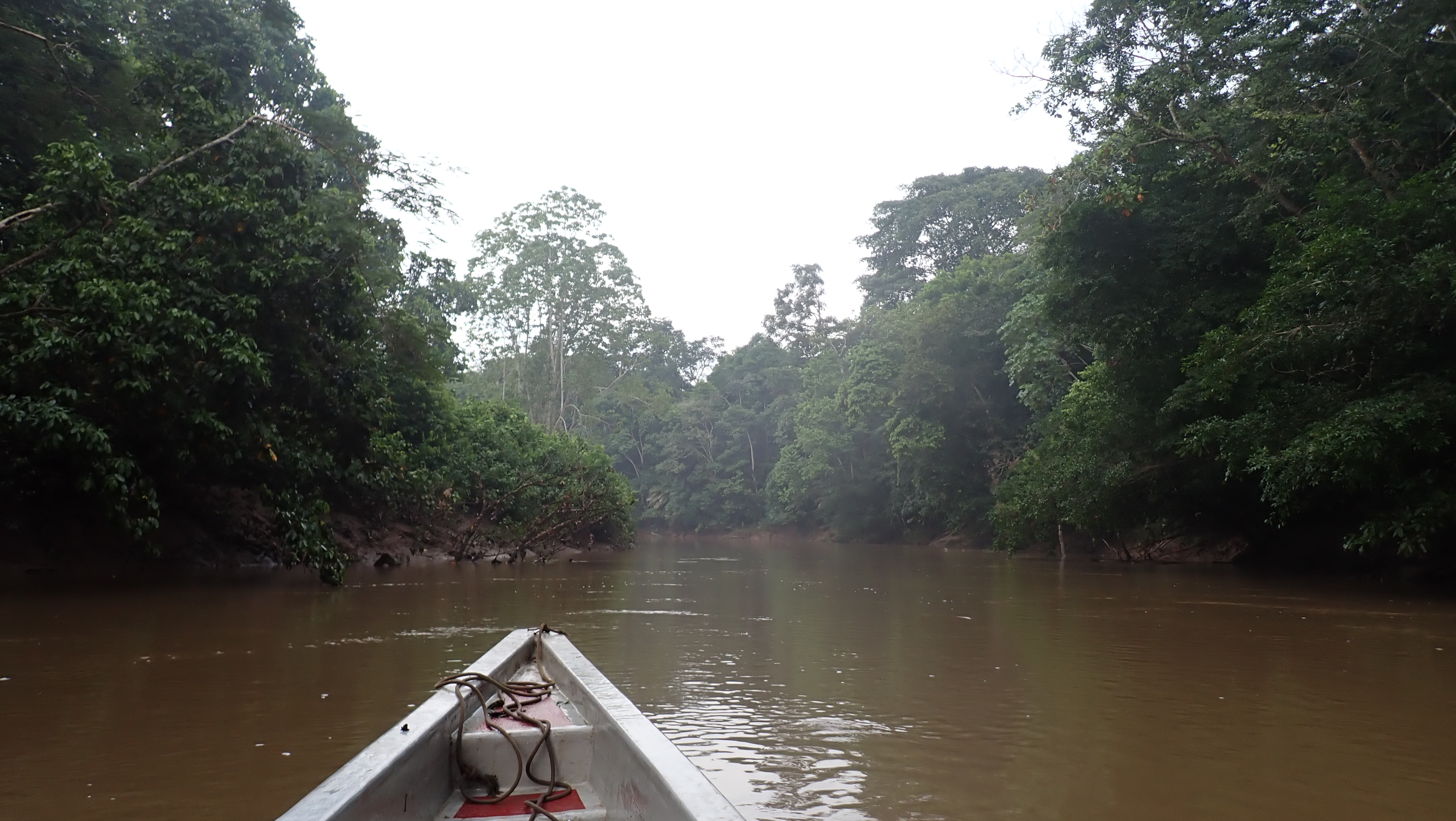
It is interesting that both Santa Cruz County and the country of Ecuador generate approximately the same amount of cash due to tourism: $1.1 billion annually. It is there that the similarities end. The Beach Boardwalk is the driving force for Santa Cruz County tourism. Experiences in nature are what drives tourists to Ecuador; they go to experience Darwin’s discoveries in the Galapagos Islands or to see the rich jungles, volcanos, mountains, and the plethora of wildlife. Everywhere you go in Ecuador there are lodges hosting people whose destination is Nature. Lodges are gateways to the Parks, and each lodge has a cadre of nature guides trained to help tourists see the richness around them. Nature guides study for years to become certified to lead tours in the parks. The guides I met could identify hundreds of birds by their songs, knew a bit about most of the plants we encountered, could identify tracks in the mud, and could talk about the distribution of species across the country and beyond. There are hundreds and hundreds of such guides in that country, which is the size of Colorado.

What a Contrast!

As I returned home, I wracked my brain to think of a single lodge in the Monterey Bay that caters to nature tourists and has any nature guides at all. The San Francisco Airport toilets were much nastier than the toilets in the Quito airport. Trash litters Highway 1. The homeless population was not sleeping peacefully, though others might have been, back in my hometown of Santa Cruz. I’m not sure how many of my culture were rejoicing, with sad music or otherwise: joyfulness is not a phenomenon I equate with this culture. Certainly, most of us living around the Monterey Bay aren’t living poor, but we, like Ecuador, dwell ‘in the midst of incomparable riches.’

Miles of beautiful coast and not an eco-lodge or terrestrial biodiversity guide to be found

When is a Tourist Just a Tourist?

What does it matter that tourists go to the Boardwalk versus taking a walk with a nature guide? They come, they spend, they go home…its all good for the economy, right?

Between guided hikes at an Ecuadorian lodge at 9,000’ I sat by a fireplace looking through the reading material on the coffee table. There, among giant, full-color books published by the Ecuadorian government about the nation’s biological richness, I saw a magazine published by the American Bird Conservancy. That group, and the Audubon Society are two fairly mainstream conservation groups working to save birds from extinction. Many of the tourists supporting Ecuador’s lodges are birders. There is a natural connection between tourism and conservation. The same cannot be argued about Beach Boardwalk visitors.

So, why isn’t there an economy of immersive nature tourism around the Monterey Bay?

The Thrill Isn’t There and We Just Don’t Care

Thrilling, isn’t it? Roller coasters…rides…the children won’t be bored. Once the children grow up, the adults head overseas to see birds and nature: why not sooner? What is it about Nature that makes experiencing it so family unfriendly?

Even a drive along Highway 1 is so unenthralling as to invite so much littering.

Do we care so little about impressing the tourists, do we have such little pride, that we don’t bother keeping our airport toilets and roadsides clean? Aren’t we richer than that? Or, are we really quite poor?

What would Humboldt say of those currently living around the Monterey Bay? “They are just normal beings: they sleep fitfully in the midst of isolation and crime, living poorly in the midst of incomparable riches and rejoice in violent movies.”

Hoary manzanita, Arctostaphylos canescens – on granodiorite, ridgeline south of Loma Prieta

Awake! The Unfolding is Nigh

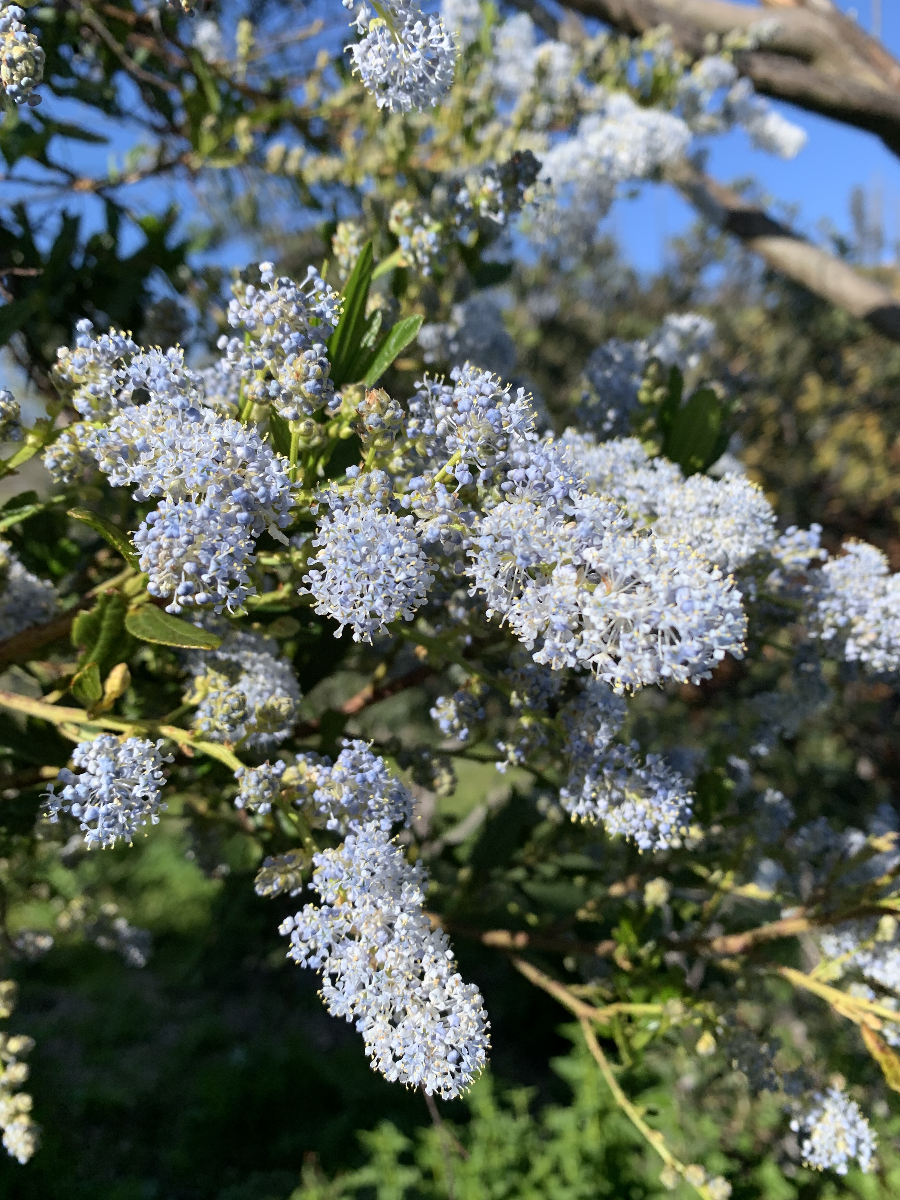
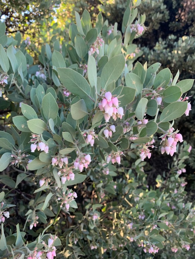
Now the rain has wetted the green hills, flowers are bursting, birds are singing spring songs, and streams are noisily dancing. The solution is at hand. Toss aside the social media, decline the invitation to the movies, take the trail and saunter. Invite someone to join you, someone with whom you can adventure and discover the amazing life unfolding around the Monterey Bay. First on the list: the manzanitas! A dozen species within a short drive – discover them all, their beautiful bark, their honey-scented flowers with hummingbirds and bumble bees aplenty. Jackrabbits and brush bunnies, roadrunners and quail, coyote and mountain lion tracks around every corner. Need a guide? Sign up for a walk if you can find one: ask me if you can’t. The Monterey Bay’s ecotourist economy and resulting conservation start with you, now and tomorrow. Let’s make Ecuador a sister country to the Monterey Bay – biodiversity hotspots with plenty of inspiration to share.

-this post originally appeared as part of Bruce Bratton’s laudable BrattonOnline.com weekly blog: check it out! Subscribe! Support! It is The Place for news on the Monterey Bay. No other outlet supports a regular environmental column. Other outlets have SUBPAR environmental reporting.

See, You Know This!

You’ll soon be familiar with one of this area’s most important native shrubs and its ecological interactions. The best poets, writers, and film makers have intimate familiarity with plants and ecosystems, enabling them to transmit their hearts and imaginations realistically. To be part of this place, to appreciate the nature around us, you might consider doing the same. Most start with the dominant trees – those are easy…aim for 10 species, and you’ll have a great start! The next step is to name and know the stories of the top 10 dominant shrubs. In this case, you’ll certainly include a shrub with a confusing array of common names: California lilac, blue blossom, wood tick bush, soap blossom, or (in yesteryear) blue myrtle (Ceanothus thyrsiflorus).

Whatever you call it, this shrub is starting to blossom right now with long fat clusters of tiny pale blue flowers, shaking with pollinators, and filling the air with incredible perfume.

Syringia vulgaris, common lilac, a denizen of gardens and native to Eastern Europe

Wild Lilac?

California lilac isn’t even closely related to the ‘normal’ lilac, but it is easily as commonly found in gardens. The European lilac is related to olives, has medium-sized leaves, and 4-petaled flowers with heady, sweet perfume. Our native wild lilac has a dusty-sweet scent, but you’ll have to squint or use a magnifying glass to see that the tiny flowers have 5 petals.

Garden Plants

There are many relatives of blue blossom, and you can even find some side-by-side in our area. My favorite is warty leaved Ceanothus, Ceanothus papillosus, which likes to grow in chaparral. This warty-leaved type has sapphire-blue flowers and a very memorable, sweet-resinous smell emanating from its leaves, especially when it is hot out. This diversity of Ceanothus types and their stunning beauty have made them very popular as garden plants. If you have well-drained soil and some space in your garden, you might consider adding one not only for their flower beauty, but for their evergreen beautiful leaves, as well as their attractiveness to wildlife. You can find forms from tight ground covers to tall and treelike with flowers from white to deep, dark blue. The flower scents are that variable, too- from very sweet to very musky.

Twenty Years Ago

Twenty years ago, it was a much more unusual treat to encounter California lilac in the natural landscape around Santa Cruz. The same can still be said of the areas that haven’t burned in anyone’s memory. Big, burly blue blossom could hardly be called a shrub back then; they seemed more like small trees, with 1’ thick, gnarly trunks and barely organized canopies festooned thickly with pale blue flowers. Those powder blue puffs stood out singly or in small groves, poking up through old manzanitas or coyotebrush, visible a half mile away for their brief flowering period and then disappearing for the remainder of the year, blending in perfectly.

And Then There Was Fire

California lilac is a pyrophile. How can life love fire, such a destructive force, cooking and searing plants and animals alike as the wind-fanned flames race across hill and valley, crackling and hissing, turning everything to smoking char? For blue blossom, there is naturally no next generation without fire and adults are lucky to live 50 years. These shrubs make a lot of seeds, which sit in the soil waiting for the winter after fire to germinate. Sleeping seeds awaken when they feel the sun and the sun-warmed soil, then seeds that have accumulated in the soil for years germinate. Carpets of blue blossom seedlings spring up, and 3 years after the fire are 6’ tall and blooming, soon raining seeds in preparation for the next fire birthing.

Getting Around

Blue blossom seeds don’t appear adapted to dispersing far from their parent shrubs. The seeds don’t have maple seed wings or dandelion fluff to disperse on the wind. And, the seeds don’t have obviously attractive fruit like acorns or avocados. But, when the seed pods explode on hot days, cracking and popping seeds loose from the mother plants, wildlife become alert to the new availability of food. Quail have been known to gobble them up, as they scratch and peck in the shrubland understory. But quail and other birds don’t digest the seeds completely: the result, perfectly viable seeds being spread across the landscape, far from mother plants.

Not Just Fire

California lilac doesn’t require fire. Any disturbance that churns up the soil and shines new sunlight onto the seeds will work just fine. So, you can find new shrubs germinating in the wake of road or trail building, logging, and even suburban gardening. There are many other sneaky species like this: ones that appear abundant after fire, almost as if they require fire to germinate. There are many fewer species that do actually require fire to germinate- many of those are triggered to sprout by chemicals leached out of charcoal in the winter rains following wildfire.

Such nice flowers on that California lilac: I wish you could smell them!

California Lilac Uses

What good is this shrub? The vigor of this species in germinating after wildfire may be important for a few reasons. First, the shrubs might help to cover and then hold soil in place after fire. Second, the species has special roots that allow it to capture atmospheric Nitrogen and make it available as a plant nutrient. Adding this fertilizer to the ecosystem may help adjacent plants to grow and recover after wildfire. Blue blossom tends to grow especially well on poor soils, so it may be assisting many other species to make it in this soil-inhospitable situation.

Moths, Butterflies and Other Insects

Besides being good bird seed, moths and butterflies depend on California lilac. Ceanothus silk moth feeds on this species (its cocoons were used ceremonially by tribal peoples); many other species of butterfly and moths likewise raise their young on blue blossom. Tortoiseshell butterflies migrate from the Sierra Nevada to raise their young on blue blossom here along the coast. Somehow, the young know how to get back to those mountains to raise their children, which in turn fly higher in the Sierra and that high-mountain-raised generation is the one that comes to the coast.

Besides the post-fire explosion of tortoiseshell butterflies, one of my favorite phenomena are the annual gatherings of what I call blue blossom dancers. Thousands of tiny beetles fly in clouds above the blossoming shrubs at sunset, their silver-shining silhouettes are fascinating to watch pulsing and undulating in their fantastic annual ritual dance. Throughout the day, you can see those dancers feasting on pollen in the flower clusters, preparing for their energetic sunset display.

Where to See Blue Blossom….and a Cleaning Trick

Head for the post-fire ecological footprint! I hear that some Big Basin trails are open as are the trails in the Fall Creek Unit of Henry Cowell State Park. Both areas have huge rafts of California lilac just starting to flower. It is worth going before the winds on a warm day to immerse yourself in the scent. Do yourself a favor and get close to the flower clusters to see the awesome diversity of pollinators. If there is water nearby, grab a big hank of flowers and get to the water. Holding the mass of flowers between your wet hands, rub them together and you can experience the sudsy nature of soap blossom. Like apricot scrub, it has just the right amount of abrasiveness to help the nicely scented suds help clean your hands.

See, you know this! Ceanothus. You are on your way.

-this post originally made available via Bruce Bratton at his BrattonOnline.com blog; check it out…weekly updates…the BEST local news source in the Monterey Bay area.

Our Local, Endangered Pine Species

Monterey pine (Pinus radiata) is an extraordinarily valuable endangered species that has received insufficient conservation recognition. The stand of pines around Año Nuevo have been heavily impacted by wildfire but are regenerating well (for now). Meanwhile, much of the Monterey pine stand on the Monterey Peninsula is effectively gone. Cambria’s Monterey pine forest has likewise been compromised. In both cases, while there is what appears to be Monterey pine forest in and among homes, those trees are what are termed ‘relictual’ – without fire, they will not regenerate and no one is suggesting that prescribed fire be used in neighborhoods to manage those forests to perpetuate them as they would naturally need to be. In an ideal world, homeowners in Cambria and on the Monterey Peninsula would be so interested in conservation that they would participate in an expensive program to replant older pines with enough genetically appropriate seedlings as to maintain those populations, but we have too little leadership, interest, and funding to support that kind of initiative. My hope is this becomes a reality. The first step is to build awareness and interest. Your job is to help tell this story to increase support for the protection of this pine. The next step is to gain State legal protection of this endangered species.

Timber Importance

Monterey pine is an enormously important tree for producing timber around the globe. Some of my advisors suggest I start any argument for conservation in the economic realm, and so I start here. If you are going to discuss this tree in this context, the first thing you need to do is to use the correct terminology, starting with the right name for the tree. Call the timber tree ‘radiata pine.’ That’s because it has been so intensively bred as to be easily distinguished from its wild counterpart.

10 million acres of radiata pine occur in timber plantations, mostly in Australia, New Zealand, Spain, and Chile.

As the effects of climate change intensify, it will become increasingly important to maintain and adapt the genetics of radiata pine. While there is some genetic diversity already embedded in plantation radiata pines, there will inevitably be a need for wild genes to augment the plantation trees. And so, conservation of the wild populations becomes important even to the timber industry. Because the wild populations are distant enough from each other, each population has unique attributes that would be important for the health of radiata pine for future timber production.

The Five Pine Populations                           

There are five wild Monterey Pine stands, three in California and two in Baja, Mexico: Año Nuevo, Monterey, Cambria, Cedros Island, and Guadalupe Island. The Año Nuevo stand is the largest, growing from southern San Mateo County in the north to near Bonny Doon Road in the south. The Monterey stand is bounded to the north by Highway 68 and then into the northern Big Sur to the south. The Monterey stand occupies a series of ancient marine terraces, each with very different soils, an ‘ecological staircase’ with each terrace supporting very different biotic communities. As you move up the staircase, the pines become increasingly short-statured due to age of the soils increasing and, therefore, the soil fertility decreasing.

The population in and around the town of Cambria. There are also two very odd populations on islands to the west of Baja California. Cedros Island is 14 miles offshore of central Baja and Guadalupe Island is 130 miles offshore of northern Baja Mexico. The Guadalupe Island population has historically been highly threatened by goat grazing, but goats have been recently controlled and now there is hope. The Cedros Island population fares better. The two Baja populations of Monterey pine stand out in having only 2 needles per bundle as opposed to the 3-needle bundles from the other populations.

Local Importance, Local Threats

Superficial consideration might suggest that Santa Cruz County’s Año Nuevo stand of Monterey pine is well protected, but there are important issues to consider which might lead to different conclusions. This stand of endangered pines is the largest and much of it is located on property where the owners are amenable to good stewardship. And, this stand is also likely the origin of the plantation ‘radiata pine,’ and so contains the historical suite of genes that have been so important to forestry. This location is the only one where Monterey pine hybridizes with another species – knobcone pine. Sometimes, people refer to ‘hybrid vigor,’ and breeders once saw that expressed from trees grown from Año Nuevo stock in their trials as they selected the best trees for plantations.

Although the Año Nuevo stand has strong potential for conservation, there is no plan to guide that conservation and no leadership in convening and focusing that stewardship. An invasive pathogen, pine pitch canker, has the potential to continue spreading, killing up to 80% of the trees. Other pathogens will no doubt be introduced due to carelessness in regulating global trade; those pathogens will likely be spread along recreational trails and roads through the population. There is also the issue of fire…

The 2020 CZU Lightning Complex Fire raged through most of that population spurring (in patches) a whole new generation of trees. How frequently will the stand burn is an important question – too frequently and the pine may be unable to persist for many more generations.

Fire Adaptation

For millions of years, the distribution and health of Monterey pine has been shaped in a dance between fire and fog. Not too long ago, Monterey pine circled the Monterey Bay, but it has persisted only in the foggiest and most fire-free areas. With climate change, wildfire is expected to increase in frequency and intensity. The 2020 fire left large numbers of dead pines and other trees standing; those present a massive fuel load for subsequent fire(s). With so much fuel loading and anticipated increased fire frequency, I am concerned that fires will become too frequent and intense for adequate regeneration of Monterey pines. For those of you who want to view a now very rare healthy and diverse Monterey pine forest, I strongly recommend that you visit the very few remaining areas very soon.

Where to Go                                                                            

While it will be instructive to see how Monterey pines are regenerating from fire at the Año Nuevo stand, it is perhaps more enjoyable to see mature stands near Monterey. Within the Año Nuevo stand, you can see post fire regeneration by gazing into the forest along Highway 1 at Waddell Creek beach. If/when BLM opens its northern trails at the Cotoni Coast Dairies, visitors will be able to glance one of the southern-most patches of the Año Nuevo stand of Monterey pine is on a hillock above those trails. Near Monterey, the Huckleberry Hill nature preserve is worth seeing as is Point Lobos State Park and Jack’s Peak park.

What You Can Do

In 1999, the California Native Plant Society petitioned the State of California to list the species as Threatened; the State however refused to consider the petition due to lack of staff resources/time/money to adequately process the petition. This example joins a plethora of other similar situations: the State of California needs citizen support to allocate the necessary funding to list deserving species as Threatened or Endangered so that they will be adequately protected at the local level. We should all be writing to the California governor and our local state assembly and senator members to ask for increased budget and attention to promulgating and analyzing listing petitions for species including the Monterey pine. Here are the contact emails: Governor Newsom, Senator Laird, and North County Assemblymember Gail Pellerin or  South County Assemblymember Robert Rivas.

-this article orginally published in my weekly column at BrattonOnline.com, where Bruce Bratton’s team updates our community about local issues from experts who tirelessly track such things. Thanks Bruce!

Democracy and the Environment

I like the phrase ‘all politics is local’ and have coined a corollary phrase ‘war starts at home.’ We must find solutions that work at the local level, including resolving conflict. My twist on these issues has an environmental focus, and I want to illustrate our local situation in this essay.

Voting

If locals were judged for those they elect, how environmentally-minded would anyone think we are? I can’t think of a single local city council member who purports to prioritize environmental conservation. None of our County Supervisors advertises environmental conservation as a primary concern. Likewise, the local State Assembly members do not have strong environmental conservation platforms. Only when you reach the level of State Senator do we get an inkling that our local constituencies support environmental conservation: John Laird has long been an effective environmental conservationist, and conservation is one of his main priorities.

As we consider voting, how are we to be informed about which candidate might best serve environmental conservation? My experience has been that it is not easy. Unfortunately, there is no reliable environmental conservation organization informing local votes through their endorsement process. The Santa Cruz Group of the Ventana Chapter of the Sierra Club used to serve this important role, and the Group still ostensibly considers making endorsements – apparently only if a candidate seeks their endorsement. For 2022, the Group posted a list of endorsements, though without any analysis explaining their reasoning. Upon examination, most of the candidates they endorsed had little or no mention of environmental conservation in any of their election materials.

Lacking other means, you must follow environmental issues yourself and watch how politicians and political candidates react to those issues. Even if you track a single issue, you will find it helpful in illuminating for whom you should cast your vote. As a reminder from my past columns, priority environmental conservation issues for our area include: habitat protection for maritime chaparral and coastal prairies, creek and river habitat conservation, water pollution, and wildlife habitat connectivity/corridors. Of course, there are many issues to address when conserving rare and endangered species throughout our region, and those must be prioritized as well. If one of those priorities strikes your fancy, watch it carefully to see who is active and how politicians navigate to address them…and vote accordingly.

Environmental Advisors for Politicians

One of the ways environmental conservation conflicts might get resolved is through governmental advisory bodies. Locally, cities and the County have advisory bodies that ostensibly COULD advise on environmental matters. However, I cannot think of a time when City Council Members or County Supervisors sought out those advisory committees for advice, let alone acted on any of the advice otherwise offered by those committees. I suppose that’s a reflection of politicians’ assessment of how much local voters care about environmental matters. You might ask yourself, ‘are there environmental conservation conflicts locally?’ I hope you recognize that the answer is, ‘yes.’ The next question is ‘how are those conflicts being addressed?’ The answer is, ‘they are not.’ ‘Why?’ The answer to that question is ‘one side, the one in power…the one that destroys the environment…is winning.’ Why would anyone seek to resolve conflict when they are already winning? Two reasons come to mind: the primacy of environmental conservation for life on Earth and, consequently, avoidance of war which is the natural result of the degradation of the environment. All politics is local, and we’ve punted on this issue to our peril.

The following section lists the advisory groups that could be tasked to help resolve environmental conflicts, should politicians ever realize the importance of doing so.

City of Santa Cruz

The Santa Cruz City Council has a Parks and Recreation Commission to advise the City Council. Unfortunately, as reflects the views of the politicians who appointed them, the majority of those advisors care so little for environmental conservation that they fail to address those issues as part of their advisory role. This is a shame because the City’s parks contain a wealth of biological diversity, including many rare and endangered species, and these advisors could be valuable in helping to address most of the priorities I outlined above.

County Political Advisors

The County curiously has two bodies to advise the Supervisors about environmental matters: the Fish and Wildlife Advisory Commission and the Commission on the Environment. The Fish and Wildlife Advisory Commission membership historically has included a majority of experts with strong environmental conservation track records. After years of that Commission, there was the anomalous creation of a second advisory body, the Commission on the Environment – this one appointed with a majority of members without any environmental conservation interest, expertise, or experience. If you’ve got insight into why that second commission was convened when Supervisors could easily turn to the first, I’d love to hear from you.

Joining Together: Activism

Another way locals can affect change democratically is through organized activism. The list of environmental conservation groups acting at our local level includes the Valley Women’s Club of San Lorenzo Valley, California Native Plant Society, Land Trust of Santa Cruz County, Watsonville Wetlands Watch, Surfrider, Friends of the North Coast, Friends of the Greenbelt, Friends of Pogonip, Save our Shores, the East Meadow Action Committee, the Habitat and Watershed Caretakers and the Santa Cruz Group of the Ventana Chapter of the Sierra Club.

From time to time, other groups including Audubon Society, Earthjustice, the Xerces Society for Invertebrate Conservation, the First Amendment Project, Save the Redwoods League, Peninsula Open Space Trust, Sempervirens Fund, and the Center for Biological Diversity have stepped into the Monterey Bay area to assist with environmental conservation.

Each of the groups above has a history of success in their own issue areas in our region. But, even with all of their work, major environmental crises still plague our area and are going virtually unaddressed. Those crises are getting worse. And, despite the work of all of these groups, we have the bleak political landscape that I outlined in the opening of this piece. Simply put, none of those groups has affected the political change we need to sustain environmental conservation in our region.

Rating Activist Groups

If we want to donate money or join a group, how do we know how effective it is? Unfortunately, there isn’t an organization that rates our local conservation groups for their effectiveness. Nationally, if you want to give money to a group for environmental conservation, you might use Charity Navigator to peruse groups’ effectiveness. But that group’s ratings don’t really reflect our local situation. For instance, if you looked at the Sierra Club, you might find Charity Navigator’s high rating for the Sierra Club Foundation, whose work (despite the nomenclatural similarity with the Sierra Club Santa Cruz Group) doesn’t address our local conservation issues. Here again, if you follow even a single local issue, chances are that you’ll get to witness the effectiveness of a local conservation group. I know the groups I’ve been impressed with…but, we have so much more to do!

Working Together to Healthy Nature and a Lasting Peace

Only by working together, through democratic institutions and processes, by supporting the leaders and groups that are most effective, can we create the local changes from which others can learn. Together, starting locally, we will create a world that embraces successful environmental conservation and achieves a lasting peace. I hope that you will do something to help.

-this post originally published at BrattonOnline.com, a dependable source of interesting information especially for the Monterey Bay area. Sign up and enjoy.

Conservation Land Management: Critical Thinking about Local Matters

When you visit conservation lands, how do you think critically about stewardship? There are various things to consider and ways you might help.

The Balance

Often conservation lands managers mention their obligation to balance conservation with public access. In our area, this is especially true for State Parks and the Bureau of Land Management (BLM). Here are some Mission Statements to help you understand:

State Parks Mission: “To provide for the health, inspiration and education of the people of California by helping to preserve the state’s extraordinary biological diversity, protecting its most valued natural and cultural resources, and creating opportunities for high-quality outdoor recreation.”

BLM’s mission is “to sustain the health, diversity, and productivity of America’s public lands for the use and enjoyment of present and future generations.

The normal thing to do when analyzing how to provide a balance between recreational access and conservation is to perform a carrying capacity analysis, which defines ‘limits of acceptable change.’ Monitoring determines if limits are surpassed, and adaptive management reacts with changes to public access patterns to address any problems. If the carrying capacity analysis process were integrated into a collaborative natural resource management program that welcomed public participation, controversies about changing and limiting public access could be managed with more understanding and cooperation.

Visitor Use Expectations

If they followed state of the art management practices, conservation lands managers would consistently determine what prospective visitors expected and adjust to meet those expectations. Expectations are monitored through interviews and surveys not only of people actually visiting the conservation area, but also prospective visitors in the general population. Managers normally encounter a great deal of diversity of expectations from conservation lands visitors. Some want active recreational experiences – trails/roads to jog along or mountain bike; some mountain bikers even want “rad” experiences involving tricky terrain to navigate at high speed on single track trails. Other visitors hope for quiet, contemplative strolls, opportunities to observe wildlife, or safe places to walk with elderly or very young family members. Still other portions of the population want to recreate on motorized vehicles, fly kites or drones, or rock out with parties involving amplified music and dancing. And, other segments of the population want places to meditate, collect medicinal herbs or edible mushrooms, help with stewardship, or take photographs. Obviously, it is impossible to provide everything to all people on any given parcel of conservation land, but how can managers decide what to do?

Meeting Whose Expectations?

Conservation lands proponents are sensitive about meeting many different expectations because they perceive benefits of increasing the public’s support of conservation lands acquisition, which is expensive. Sometimes this is complicated because lobbyists for various recreationally-oriented businesses are good at amplifying their client’s voices to advocate for specific types of visitor use. Traditionally, hunter groups and off highway vehicle organizations achieved successes this way. More recently, mountain biking organizations have been similarly influencing conservation lands management. Proponents of conservation lands acquisition dodge the tricky nature of favoring some types of visitors over others by public cheerleading for ‘maximum public access’ while privately providing pressure for a small subset of visitors, usually those they think are most politically influential. This is why State Parks managers opened Wilder Ranch hiking trails to mountain biking without any analysis or planning, welcomed the public onto the Coast Dairies’ beaches without environmental review, and allowed a private organization to operate a parking lot, gift shop, and privately controlled entrance to Castle Rock State Park. This is also why the Bureau of Land Management will soon allow e-bikes to use trails at Cotoni Coast Dairies. BLM is also planning on crowding all visitors onto trails that will be so heavily used as to spurn contemplative users while disturbing wildlife enough to alienate bird watchers. Families will have their hopes dashed of viewing sensitive wildlife such as bobcats, badgers, and foxes, species that frequent the property before the public has been admitted.

Coastal Commission Cahoots

I would be remiss if I didn’t remind readers that the much-lauded California Coastal Commission has been a close party to such poor ‘maximize public access’ decisions. Politicians have long appointed Coastal Commissioners who agree to the (bogus) ‘maximize public access’ mantra and who consequently believe that protecting nature gets in the way of their political success. Likewise, staff who support this schtick are empowered and promoted…and an organizational culture has been created that knows little else. And so, our beaches, bluffs, and coastal parks are being overrun by visitors, vegetation trampled, hillsides eroding, and wildlife quickly disappearing.

Quality Experience

In our rush to maximize public access, we are losing the quality of visitor experience. Social scientists have long understood that conservation lands visitor expectations can erode based on what is “normal” to experience. As levels of trash increase, people expect trash…and become more careless about leaving trash in natural areas. With poor planning, parks become more crowded, and people lose expectation of contemplative experiences, nature becomes less healing. As over-used, badly managed trails erode into ditches with holes, elderly people stop visiting their favorite places; the average age of visitors grows younger and younger. As poorly educated conservationists work together for the ‘maximum use’ paradigm, families stop expecting to teach their children about wildlife from first-hand observation and the conservation movement loses wildlife advocates.

Oh, But Funding!

Enter into conversation with conservation lands managers with these critiques and the conversation quickly turns to lack of funding as the excuse. ‘We just don’t have the funding to….’ While I am compassionate to lands managers that they face a very dire funding situation, I posit that such poor funding is a result of bad decisions by individuals within their organization and lack of enlightened leadership in the conservation community.

When you hear complaints about funding, I encourage you to ask some follow up questions, like: ‘Have you completed “Carrying Capacity Analyses?”’ ‘Have you delineated “Limits of Acceptable Change?”’ ‘What has your monitoring revealed about the trends of sensitive plant and animal populations on your land?’ ‘How have you managed for changing visitor use and visitor expectations over time?’ If conservation lands managers prioritized addressing those questions in collaboration with the conservation community and the public at large, funding would be less of an issue. When visitor use is curtailed within the collaborative and adaptive management context, there is increased political support and funding for stewardship, planning, and improved alternatives that better address visitor expectations.

What You Can Do

See something, say something. I encourage everyone to speak up and vote for these issues. Any politician at any level must interact with these issues in some way: they should have clearly stated policies that they support to improve conservation lands management. And, they should know the term ‘carrying capacity analysis’ and support the practice as it relates to conservation lands management.

And, if your expectations are not met when you visit conservation lands, you should let the managers know. Are the trails in good shape? Did you see wildlife? Was it too crowded? Did you feel comfortable with the other kinds of users on the same trails? Was there trash? Were bathrooms adequate? Did you and your family feel safe?

Finally, ask conservation lands managers the questions posed above. Also, ask how you might help to manage and monitor within their defined carrying capacity, or how you might then advocate for increased funding for their adaptive management. These dialogues could help immensely.

-this article originally published by Bruce Bratton at his weekly BrattonOnline.com, an invaluable piece of journalism helping thousands of people keep in touch with what really matters around the Monterey Bay area of California. Subscribe today- better yet, donate to keep it going.

Newt and Salamander Weather

We live in a very rich area for salamanders and newts. And, when it starts raining, everywhere becomes newt and salamander habitat.

The Menagerie

Right nearby, if you went searching, you could find 8 salamander species: Gabilan and California slender salamanders as well as arboreal, California giant, Santa Cruz black, Santa Cruz long-toed, and tiger salamanders, and then the oddly-named yellow-eyed Ensatina. Add to that our two local newt species – rough skinned and Coast Range newts – and you will realize how much there is to learn about these 10 species.

Where do you find these creatures? Well, that depends….let’s start by thinking about their most vulnerable life history stage, when these creatures are teeny tiny eggs.

Pond Breeding

The newts and some of the salamanders depend on aquatic habitats for breeding, and that’s where they lay their eggs.

Dark, long-lasting, deep shaded ponds are the easiest place to find newts. Interestingly, both the rough skinned and Coast Range newts are found in our area. Some ponds have both species, but other ponds just have one or the other. These newts attach balls of eggs to sticks, roots, and such to make sure that the pre-hatched babies are nurtured in the right depth of water, in the right amount of shade, with the right amount of cover. In the right part of the Monterey Bay, those same egg-laying spots in shady ponds are also coveted by another salamander…the endangered Santa Cruz long-toed salamander, which is found only in southern Santa Cruz and northern Monterey Counties.

Those 2 newt species also can raise babies in warmer, sunny ponds, where another species of salamander is also found. California tiger salamanders love those warm pools, rubbing elbows with western pond turtles, western toads, and California red-legged frogs. These are often grassland ponds managed by ranchers to provide water for cattle. Tiger salamanders like to attach their eggs to pond debris, and you can find their eggs in ponds from southern Santa Cruz County into ponds across Fort Ord and beyond. Our population of California tiger salamanders is protected by the federal government because they have been listed as Threatened under the federal Endangered Species Act.

Spring and Creek Breeding

Those 2 species of amazingly adaptable newts can also raise eggs in stream pools, but streams aren’t the best place for wee newts or salamanders. As you might have seen from this winter, streams get flowing pretty fast, and eggs would soon be headed into the salty sea! So, newts head to streams in the spring as soon as the storms calm down where they raise a summer brood. That spring movement also coincides with the mysterious migration of California giant salamander larvae. The biggest of our local salamanders, the rare California giant salamander probably raises most of its eggs in the muck, under the gravels and among the woody debris of near-stream springs and seeps, safe away from raging floods. Once hatched, the larvae must wriggle and flop downslope into streams. Head upslope, and there are still more odd salamander egg-raising habits.

Eggs Out of Water

A few salamanders raise eggs on what is broadly known as ‘debris,’ but they are probably more picky than we understand. I’ve seen and heard about the rare and only recently described Santa Cruz black salamander tending eggs in gaps on pieces of hard rock…near streams or in moist areas. Those beautiful star-studded sallies are nearly impossible to spot, and there are so few places known that I can’t share a place that you could go to spot them. You are much more likely to encounter arboreal salamanders, maybe even in your neighborhood park if there are native oaks nearby. Those toothy arboreal salamanders place their eggs in moist tree cavities…or ‘in debris.’ Similarly, California (northern Monterey Bay) and Gabilan (central  Monterey Bay) slender salamanders place eggs ‘in debris.’ Then there’s the yellow-eyed Ensatina, which I’ve only found in holes and bark of big, rotting moist logs – again ‘debris.’ In case you haven’t gathered – there is a lot to learn about ‘upland’ salamander egg placement and what constitutes nesting ‘debris.’ Share your observations with me on this group, if you’ve seen something interesting!

Groovin’ and Movin’

Their eggs need water or at least moisture-laden debris, but when it is raining newts and salamanders are EVERYWHERE. That’s bad news for them because of the many roads replete with squashing tires of fast-moving vehicles. But, let it rain and adult newts and salamanders take the opportunity to move around, and they sure can move!

In the pouring rain, I’ve encountered California giant salamanders hiking streamside redwood fire roads. In the middle of stormy rainy nights on several occasions, I’ve found arboreal salamanders on my porch. By the second winter of age of a brush pile, slender salamanders have somehow used the cover of drizzly nights to find their way under the stacked branches…hopefully not going to get cooked by a feckless fuel reducing pyromaniac. On those same rainy nights, yellow-eyed Ensatinas stretch their tiny legs to crawl across the forest floor to crawl up and then wedge themselves in just the right rotten bark plate of a 3-year old downed fir.

Meanwhile, the first winter storms see California tiger salamanders hiking along cattle trails in the meadows to find new ground squirrel holes to call home for a while. Because of their rarity, scientists have actually monitored this salamander’s movements…up to 1.2 miles out of ponds and then across the wide-open grasslands! Like tiger salamanders, newts also move far across the uplands. Newts, tiger salamanders, and perhaps Santa Cruz long toed salamanders tend to move in great big groups during the nights of the first biggest rains. Along Carmel Valley Road – and hopefully in more places, soon – you can see signs warning about newt migrations. Migration areas aren’t extensive: they are normally fairly concentrated. Some folks are trying to create underpasses where rare salamanders can safely cross roads…the problem being how to guide them to those narrow culverts or bridges.

They Need Your Help

How can you help our area’s rich newt and salamander diversity? If you live in the country, the first best thing you can do is to not drive at night during the first 3 storms of the winter. You can see the weather forecast…get your groceries early and cancel your evening appointments. Then convince your neighbors and friends to do the same…figure out a way to remember this next rainy season! This past year, the migration was narrowly restricted to the early December storms in our area. Since then, there have been very much fewer newts and salamanders on the roads.

Likewise, watch where you walk in the forest- newts are constantly wandering around dark, moist forest trails all winter.

Oh, and did you catch that need for debris? It seems our inclination to ‘clean up’ debris. Wherever you can keep debris around – logs, sticks, brush – those are newt and salamander habitat. Likewise, for those of you looking to do some fuel reduction, it is best to move the contents of your brush pile, branch by branch, onto a burn pile a few yards away from where it has been stacked for more than a month.

Finally, whenever or however you can…let’s restore more native plants to our landscape- the newts and salamanders all eat bugs and there are more bugs emanating from diverse, native ecosystems.

-This column originally printed by Bruce Bratton in his BrattonOnline.com blog, which contains a wealth of intelligent writing: sign up for a weekly feed!

The Elusive California Nutmeg

When I mention the California nutmeg tree to local people, I find most folks aren’t familiar with it, so this article might serve as an introduction to one of our least-known evergreen tree neighbors.

Image thanks to: Krzysztof Ziarnek, Kenraiz, CC BY-SA 4.0 https://creativecommons.org/licenses/by-sa/4.0, via Wikimedia Commons

Needles to Say

California nutmeg has needles for leaves, and those needles hurt. Pines have needles in bundles, cypresses leaves are scales, and the local firs and redwoods look more like nutmeg in having single, short needles emanating along stems. Douglas fir stems have needles facing up and down and all around. Redwood and nutmeg trees have neater looking needles that just stick out the sides, along one horizontal plane. You can tell redwood and nutmeg needles apart because the latter have very sharp points. Because of the size and sharpness of the spines, nutmeg needles rival the painful jabs of blackberries and thistles.

Needles Afire

I was taught that redwood trees were the only conifer that could have more than half of the needles singed off a tree and still survive. I was taught wrong. The 2020 CZU Lightning Complex Fire scorched through many acres with California nutmeg- I haven’t found one that died from the blaze. Instead, just like coast redwood, the trees are either sprouting from their bases (if severely scorched) or sprouting new leaves and branches from their trunks and limbs. As an aside, I also had a Norfolk Island pine that also burned entirely but is resprouting…so, there appear to be more fire-sprouting conifers than once was thought.

The Wood

The wood of this tree is prized, but the tree is so uncommon that harvest is strictly non-commercial. The tree is not generally quick growing so it has close growth rings. And, the wood is quite different than any other wood around: it is a rich yellow-brown. I’ve heard lore that the native peoples used the wood for bows; people have mentioned to me seeing ‘bow wood trees’ where the tip of nutmeg trees have been bent over and weighted down to create a naturally curved trunk.

Conifer Fruit

This species is in the yew family. Some of you know yews, whose uses you wouldn’t guess include ewes. And, you would be right (as far as I know).

Yews are common shrubs in landscapes with bright red berry-looking fruit. Nutmegs do not make bright fruit, but their fruits are substantially odd. Perhaps the term ‘California nutmeg’ comes from examining the seed: peel off the thick rind and extract the hard nut, carve it in half and you might be looking at a nutmeg nut. California nutmeg nuts are solid and resinous like the foreign nutmeg, but our local one isn’t obviously useful as food, though some suggest the nuts may have once been used as food. Don’t eat the nut, though, it is poisonous if you don’t know how to prepare it correctly.

The coating on the nut is very interesting- watery and yet resinous and quite pungent. Squeeze the nuts and you get juicy with juice that doesn’t quite want to come off of your hand.

Medicine

Some of us recall the controversy of the cancer fighting medicine “Taxol” and the scare about losing the California nutmeg’s pacific northwest cousin the Pacific yew tree, Taxus brevifolia. Taxol keeps some types of cancer from spreading and was discovered in these yew-family trees. However, scientists figured out how to synthesize Taxol so we don’t have to rely on trees to make it, anymore.

When contemplating how to convince people that it is important to save species, I am advised to use examples like this where we have discovered life-saving drugs from wild plants. So, use this as an example.

Where to Find Native Nutmeg

I perused the herbarium records to let readers know where the public can go to see California nutmeg. It seems that the best places are in the Waddell Creek drainage from Rancho del Oso on up. One notable tree used to live near a waterfall in Big Basin- I wonder if is still there?

-this post originally published as part of my ongoing journalism in Bruce Bratton’s amazing weekly blog BrattonOnline.com

Storms and Floods

The sky has been raining sweet water across our landscape. What happens once that precious water hits the ground? Is rainwater welcome where it flows and where it ends up? Our collective actions make a big difference about how to answer these questions.

Stormy Times and Mud

For a while in the recent past, the ocean has been stormy with massive wind-blown, white capped waves. We get outdoors when we can and gaze out to sea from the bluffs, noticing bands of brown water coloring the otherwise steel gray ocean. Even streams draining relatively pristine watersheds are pulsing sediment now, providing the sand that will replenish beaches. Our mountains are naturally erosive, but humans have been adding to that erosive potential to our own detriment for far too long.

Do We Need Reminders?

Most years, winter storms remind us of certain places that routinely make the news. Suddenly, people remember that they live in drainage basins also known as “watersheds.” As winter rains commence, more people recall more often the names of rivers and streams. It is flooding time. The flooding San Lorenzo River often threatens Felton Grove and Paradise Park, causing mandatory evacuations. The Pajaro River, Corralitos Creek, and Salsipuedues likewise often pose flooding threats in Watsonville.

Floods: Non-Natural Disasters

Government and the media have trained us to call flooding a “natural disaster.” As with most disinformation, such “fake news” coalesces on grains of truth. Rain is natural. Atmospheric rivers are normal. Flooding happens naturally. Landslides and debris flows occur without human mistakes. If we didn’t have a deep geological history of erosion, some say that the Santa Cruz Mountains would be as tall as the Sierra Nevada. And yet, the frequency, severity, and impacts of damaging flooding is nearly entirely the fault of humans, resulting from poor decisions, often due to greed exercised through political power.

US Flooding History

For the USA, the best documented history linking damaging flooding to greed and political power has been focused on the floods along the Mississippi River. No one should unquestionably call floods ‘natural disasters’ after the investigations and media about Hurricane Katrina and New Orleans. I am disappointed by the cultural amnesia of the import of George W Bush’s admission that the sole book he recalled reading was John Barry’s Rising Tide: The Great Mississippi Flood of 1927 and How It Changed America. That book documented how the Mississippi’s 1927 flood propelled popular sentiment to supporting federal assistance programs for flood-ravaged communities. And so, was it any coincidence that decisions at the highest level of that Bush administration delayed federal assistance for Hurricane Katrina preparation, creating predictable levels of death, destruction, and suffering? Did these officieals actually think this was a good way to drive home the Republican party’s political message that Americans should not depend on federal governmental assistance? To shirk collective responsibility of such human-caused disasters, we must be trained to look past the decisions that ‘We the People’ made that are responsible for flood suffering. Our third-rate democracy allows greed-driven political decisions to create unsustainable levees to support short-term profits for commerce and real estate, benefiting the very few with disastrous long-term impacts disproportionately borne by the poorest, most marginalized communities. For this economic model and democratic structure to keep some semblance of function, some in power recognize that governmental assistance disaster recovery programs are important. I urge you to think about the lessons from Mississippi’s floods and national politics when thinking about local flooding and the political and media messages that entertain us during such disasters.

Recent Watsonville Flooding

Low-income housing areas in Watsonville recently experienced ‘unexpected’ flooding after levee failures. Why weren’t the residents notified? To believe the media, the fault was theirs: some hadn’t signed up for reverse 911…there was a warning! We pride ourselves with our disaster management systems. The Federal National Weather Service office in Monterey has highly skilled personnel who turn their full attention to flood monitoring, drawing data from radar, real-time rain, stream, and river gauges, and powerful computing. Flood watches come first then flood warnings. Interagency cooperation allows reverse 911 messages to be broadcast via cell phones and land lines, dedicated weather radio channels create alarms, and social media and web posts get regularly updated including pickup locations for sandbags. Emergency personnel deploy quickly to close off flooded neighborhoods.

Recent Rural Road Collapses

Landslides and trees fell across roads, blocking transportation routes for rural communities. Sometimes, the downslope side of the road collapsed. First cracks appeared, running parallel to the slope; then the side of the road slumped lower than the rest; after that, the section of road slid down the hill. Two lane roads will now have only one lane sections until The County can afford expensive repairs. Other times, the hill above the road slid down onto the roadbed, sometimes right across the road. Soil, gravel, rocks, and boulders blocked roads.  You might be able to see the top of the landslide, bare rock or dirt scalloped away, a boundary of precarious bared roots now reaching into the air. Somewhere, someone in the County is mapping the obstructions and prioritizing the deployment of detour signs and earth moving equipment while road closure maps are posted online. Meanwhile, rural residents tap into reserved groceries and try to figure out how to get to town for their jobs and supplies.

What Do We Ask?

The questions we ask about how these flood or landslide disasters occurred says a lot. Do we ask why people chose to live in such disaster-prone areas? Do we ask what history made such areas disaster prone? Do we ask how we can make people safer in the future? Do we ask how we can avoid repeating poor historical decisions that lead to such disasters? How do we prioritize which questions to focus upon? Who should be asking which questions? All these questions have answers including economic, political, and social dimensions.

Pursuing Answers

By law, real estate sales must disclose known disasters, so peoples’ choices about where to live should be well informed, but are they? It would be interesting to examine the history of the Watsonville levee failure: who built the levee – how and why? Did decision makers ask levee engineers to propose designs that accounted for historic flooding, maintenance expenses, and upstream development/land management constraints? If historical decision making was faulty, how has current decision making improved? As we recover from disasters, do we ask our elected officials to prioritize not only emergency response but also improved resilience?

Restoring Floodplains

As old, poorly designed levees fail across California and locally, we should be thinking about floodplain restoration wherever possible. Why do we continue pouring money into developing flood prone areas with real estate improvements that benefit the very few? I have been reflecting on the upswing in development of downtown Santa Cruz, which clearly is unsustainable both from river flooding and sea level rise…there are other town centers to develop that are safer! Instead, the City is pursuing treating the San Lorenzo like a big flood conveyance culvert instead of the river it is…as short-term ‘fix.’ To our south, the Pajaro and Salinas River floodplains could be restored to provide more flood protection for surrounding communities: there are many farmers willing to sell their land, but who should pay?

New Construction

As we develop new roads, trails, and other infrastructure, we should be mindful of their contribution to flooding. Is the City of Santa Cruz integrating rainwater catchment with their new developments? I see no evidence of flood mitigation with the ongoing, endless Highway 1 ‘improvements’ near Santa Cruz. The rail trail developments certainly don’t adequately address hydrological impacts. In our natural lands, there is no consistent approach to trail use to assure recreational impacts address flooding. Meanwhile, at Cotoni Coast Dairies, BLM bulldozed acres of bare soil just before this winter’s rains without any erosion control – slurries of mud and debris are flowing into streams and wetlands.

Next Steps

We can do better. Previously, I urged everyone to be involved with rain gardens – either as volunteers in public spaces or on their own lands. Cry out to the right people when you see bare soil – on farmlands or in construction zones. Only support trails groups like the Santa Cruz Mountains Trail Stewardship if/when they create soils saturation and trail use indexes that inform conservation lands managers to close and then re-open trails as appropriate and according to their purported mission to create ‘responsible outdoor recreation.’ Hold elected officials responsible to improve the resilience of infrastructure repairs/construction, enforce adequate disclosure notifications during real estate sales, and shunt new development to better areas. Together, we can be effective land stewards by fighting the greed that would otherwise cause un-natural flooding and landslide disasters in the future. We should never be cursing the rain.

-this column originally published by our County’s preminant journalist Bruce Bratton at his BrattonOnline.com weekly blog

Managing Pogonip

I recently came across my 1998 copy of the Pogonip Master Plan and was inspired to share with you some inspiration and interesting tidbits. I find Santa Cruz’ Pogonip Greenbelt an amazingly beautiful place that renews my energy, fuels my curiosity, and, each visit, shows me something new. It is so nice to keep going back to the same places for the last 33 years…to check out favorite trees, familiar meadows, patches of fleeting wildflowers that return each spring, and ancient woodrat houses. Behind this natural beauty is a web of relationships mediated by the City of Santa Cruz Parks Department and guided by the Pogonip Master Plan.

Our Pogonip Vision

In 1991, the Pogonip Task Force formulated the following vision statement for the Pogonip Greenbelt:

Pogonip is a place to be appreciated for its natural beauty, habitat value and serenity, in contrast to the built environment. Pogonip should provide the community with education and recreation opportunities that are environmentally and economically sustainable.

Weighing the Vision

Since 1991 and the subsequent adoption of the Pogonip Master Plan, how have we done with stewardship of this amazing 640-acre greenbelt? In short, we don’t know. There are no publicly available monitoring reports for anyone to understand how ‘habitat value’ has fared or whether people find ‘serenity’ by visiting there. The City’s Pogonip webpage for some reason posts a link to a private recreational organization’s article on the property, which suggests avoiding areas due to dangerous heroin dealers- that doesn’t sound serene to me. We do know that ‘beauty is in the eye of the beholder,’ so judging whether or not that part of the vision statement has been realized is too subjective.

The second part of the vision statement emphasizes sustainability, but nowhere in the document are there any metrics for judging how sustainability might be monitored. One would assume that environmental sustainability metrics for recreational opportunities would include at least soil erosion, wildlife disturbance, and invasive species or pathogen spread.

Updating the Vision

Nearly 30 years later, in 2020 the City created the more recent and very poorly done “Santa Cruz Parks Master Plan 2030” which well reflects the changing nature of City politics…to business-minded anti-environmental politicians. This plan emphasizes Park ‘assets’ – trails other types of development potential of the property – somehow overlooking sensitive habitats that were clearly delineated in the Pogonip Master Plan. It does not provide an updated vision or any new data to help us understand how well Pogonip is faring.

Don’t Yell ‘FIRE!’

The Pogonip Master Plan rightly acknowledges the importance of managing the property for wildfire, prescribing an array of management activities. Search “Pogonip Fire” on the internet and you’ll be able to peruse the many recent fires in that greenbelt. Here’s a list of the 9 easy to find ones:

July 14, 2009 – unknown acresJuly 23, 2021 – ½ acre
July 13, 2015 – 3 acresOctober 15, 2021 – 2 acres
November 7, 2018 – ? acresOctober 16, 2021 – 2 fires, ? acres
June 20, 2020 – 2 acresJune 4, 2022 – ½ acre
November 8, 2020 – 1 acre 
Recent Fires in Pogonip’s Extremely Flammable Landscape

Pretty Neat Map

Here’s a map of from the 1998 Master Plan – it has a lot of interesting things on it. First, it illustrates the ways the City was planning on managing the property for fire. Along fire roads, every 10 years the City was going to thin and prune limbs. They were also going to do prescribed burns, mow and graze. They haven’t grazed or done any prescribed fire…and the mowing hasn’t been nearly that extensive. 

Pogonip Master Plan’s Interesting Map

It is also interesting to note that there are wetlands mapped in the Upper Main Meadow…right where leaders of the Homeless Garden Project have said that there weren’t any wetlands.

Pogonip and You

This greenbelt property deserves your attention. I advise you to visit and enjoy it – there is a lot going on with wildlife, views, and amazing smells of autumn. You can join the occasional volunteer days to help do restoration- one is coming up on October 29 (email me if you’re interested)! Also, why not ask your City Council members what’s going on with the studies in the Lower Main Meadow- the area slated for the Homeless Garden Project; there were going to be lead contamination studies and a development plan by the Garden folks. Also, you might ask the City what they are doing to assure that the property is safer for fire: why don’t they graze or do prescribed fire…what about more mowing? Finally, wouldn’t it be nice to get periodic updates from Parks on the state of our Greenbelt, including how environmentally sustainable recreation is being managed…and whether the habitat values are improving or degrading?

-this article reprinted from its original location at Bruce Bratton’s online BrattonOnline.com blog- a treasure for our local community…please subscribe, donate/support!

Caring about Public Land Management

What’s going on with public land management around you, and what are you doing about it?

Most citizens of the U.S.A. state that they want healthy wildlife populations and clean water for their communities and for future generations to enjoy. And yet, repeated surveys of Santa Cruz County residents suggest declining efforts to learn about wildlife so that individuals could take action to protect assure wildlife conservation. We can see this decline also reflected in our activism and politics. When was the last time you heard about an environmental activist group taking a stand to protect local wildlife? Which politician can you name that had environmental conservation as a major portion of their platforms? Have you looked at the agendas or minutes from Santa Cruz County’s Commission on the Environment or Fish and Game Commission – both advisory bodies to County Supervisors? I challenge you to find any evidence of solicited or unsolicited advice to the Supervisors. In short, our County, at the top of the nation’s biodiverse counties, is effectively asleep while their precious natural heritage is being rapidly eroded by neglect. I frequently hear how much Santa Cruzans appreciate the wildlife, the open space, and the natural beauty of this area. If we take these things for granted and do not make efforts to be involved with conservation, I think we know what will happen to these values: they will decline, whither, and disappear altogether with time. It is time to make a shift, and the shift is best focused on our public lands management.

One of the most important things we can do as citizens of this county is to be involved with the management of the public lands around us. There are many ways to be involved in wildlife conservation on public lands throughout the region: volunteering for stewardship, rallying political support for increased conservation on public lands, and supporting environmental conservation organizations. There are three main threats facing nature conservation public lands: changed disturbance regimes, invasive species, and poor management of visitor use. I discuss each briefly in the following and present ways that you might be involved in solution for improved public lands management.

With climate change and increased development encroachment on natural areas, natural disturbance regimes, such as fire and grazing, are rapidly changing presenting a high degree of danger to nature conservation. With climate change, fires are expected to be more frequent and more severe; this is exacerbated by increased human interactions at the Wildland Urban Interface where accidental fires more frequently occur. Likewise, we have removed tule elk and pronghorn and it is becoming increasingly difficult for natural areas managers to use livestock to mimic natural grazing regimes. With both fire and grazing, public lands managers need more public funding to increase their ability to manage natural systems. There needs to be more public outcry and support for both funding and expertise within those agencies to improve lands management. Those kinds of support are also important for invasive species management. A different kind of support is needed for better management of natural areas in the face of poor visitor use management.

Badly managed visitor use in natural areas is a major cause of concern globally for nature conservation, and locally this seems to be nearly entirely ignored. The most glaring evidence that this is a problem is the nearly ubiquitous and unquestioned philosophy that increased access to natural areas is an important goal for nature conservation. Look carefully around our local parks agencies and you’ll also notice that there are no personnel trained at managing the conflict between nature conservation and visitor use, the field of study necessary to assure nature conservation in parks. The most recent planning effort for visitor use in a public park was with the BLM’s Cotoni Coast Dairies property, a real disaster in public process with recreational infrastructure development proceeding apace despite an active and unsettled legal appeal by a very small of citizens who have seen too little community support. Of the many larger, environmental groups in the area, only the Sempervirens Fund has offered publicly stated concern”Important details remain to be determined and we look forward to working with BLM to resolve them.” For the grave impacts to nature from visitor use in natural areas, there seems to me to be a need for a fundamental shift in both public perception and in the public lands management agencies to better recognize and address this issue. The following section outlines some actions you can take to help this process forward.

There are many ways, big and small, for you to be more involved with the paradigm shift needed to better address the serious issues surrounding visitor use management in natural areas. First and foremost, many more of us should become educated about the science documenting the concerns and how those concerns are addressed through social and environmental carrying capacity analysis and adaptive management. Social carrying capacity analyses define the limits of acceptable change from visitor use conflicts: conflicts between different types of uses (for instance, mountain bikers vs. passive recreational use of families with children) or conflicts due to overcrowding. Ecological carrying capacity analyses define the limits of acceptable change for soils, biota, or other natural phenomenon (for instance, amounts of trail erosion, wildlife such as cougars that are easily disrupted by visitors).

Another thing we can do to help the situation of poor visitor use management in our parks is to advocate for improvement. We should tune our senses to notice negative impacts of visitor use and then aim our activism towards change: make formal reports of issues to natural area managers, follow up on those reports, and also message higher level administration, commissions overseeing those agencies, and politicians who are invested in agency oversight. Persistence will help. Let’s also vote for politicians who promise to help. And, let’s support environmental groups who promise to work on these issues. Finally, many more people who care about these issues need to be involved with public lands management planning. Currently, mainly exploitive and well-funded non-passive recreational users are organized and vocal during these processes (i.e., Outdoor Industry Association funded groups like mountain biking advocates). Meanwhile, traditional conservation groups like the Sierra Club and Audubon Society have shied away from such issues due to either controversy or co-option. We need a new group or need to sway old groups to take these issues on.

-this article originally appeared at Bruce Bratton’s weekly BrattonOnline.com If you haven’t subscribed, I recommed it: “The last great news sources of Santa Cruz.”