My dissertation research, others’ research, and years of observation supports a need to seriously consider conservation grazing as a tool for managing the incredibly diverse grasslands of our region.
Ancient Habitat
We owe the existence of almost every bit of our local grasslands to human management of ecological disturbance regimes. For millions of years, California’s grasslands co-evolved with megafauna. 20,000 years ago, the prairies near Santa Cruz would have had herds of mastodon, mammoth, bison, ground sloth, elk, pronghorn, as well as camel and horse relatives. There were probably mastodon and mammoth trails the size of highways; like their African kin, these critters pushed over trees when drought or fire deprived them of ground-based forage.
The biomass of those herbivores was enough to evolve some amazing predators: saber tooth cats and their bigger kin the scimitar cats, a lion very close to the African lion, wolves, short-face bears, grizzly, jaguar, coyote and cougar.
About 15,000 years ago, most of that fauna disappeared, but the native peoples were stewarding the grasslands with frequent fire. Fires kept the grasslands open.
Without fire or grazing, our coastal grasslands turn to shrublands and the shrublands to forest.
Here Come the Shrubs!
First comes the coyote bush, seeds blown on the wind way downstream. First one shrub, then the next and soon there is more coyote bush than grass. As the shrubs thicken, coast live oaks take root, and they look like shrubs for years and years until they get wide enough that the deer can’t reach the center shoot, and that becomes a tree. Meanwhile, while oaks get shrubbier, here comes the poison oak and their injector friends the blackberry vines. Now, things are getting pretty impenetrable. After about 15 years, we start to see some more diversity: coffeeberry, California sage, sticky monkeyflower, honeysuckle, and others.
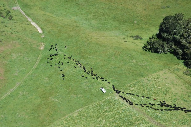
All the coastal prairies that aren’t on nearly pure, soil-less rock disappear to shrubs after 15-40 years. There are fencelines and aerial photos aplenty to show you this.
And Next…the Onset of Trees
As the shrub community closes in, the tree seedlings escape deer browse. Coast live oaks and Douglas fir rocket up from the shrub layer. Some toyon start getting tree like, too. Madrones join in.
Check out a mixed hardwood/Douglas fir forest next time you happen across one. Look at the understory and see if you can see shrub skeletons- they are likely there as a reminder from whence the trees emerged.
So, What’s the Problem? Trees are GOOD! “never enough trees….” (sigh)
California’s grasslands support the vast majority of rare plant and animal species. Globally, grasslands have been underappreciated for their diversity and function. California’s coastal prairies are one of the top ten most endangered habitats in the US. These grasslands have been converted to urban areas more than any other plant community. I bet we are still more likely to see grasslands developed locally than any other habitat type. For instance, the meadows at UC Santa Cruz are constantly under threat.
Many of your favorite wildlife species love our meadows. Deer, bobcat, fox, weasel, badger, eagle, hawk, kite, falcon, kestrel, owl, and tule elk are grassland friends. Predators require the vast production of mice, voles, gophers, and moles that grasslands create.
Even if wildlife aren’t your thing (and you’d be very much in the minority there), you might appreciate the functions that grasslands play. Grasslands can break up and cool down wildfires that would otherwise move catastrophically across the landscape. Prairies can be huge carbon and water sponges, soaking up climate change pollutants and soaking in precipitation to replenish groundwater and meter out rains to keep springs, creeks, and rivers flowing later in the season. Many folks love grasslands for recreation: picnics, lying in the sun, walking through them – all worthwhile and important activities. Grassland openness makes way for many of those favorite views. Masses of spring wildflowers create giddy laughter and attract tourists.
Oh, and grasslands raise cows…
Cows on the Prairie: Moooo!
After the genocide of native peoples, after they were driven from their ancestral homes, the prairies would have disappeared were it not for cows. The next era of grassland disturbance was the ranching era. Yes, there was a prohibition against fire. No, there were no limits to grazing. The early ranchers put way too many cows on the landscape: there were famous drought incidents early in California where dead cows littered the landscape. There is a huge slug of sediment in the Monterey Bay that is thought to be erosion from poor grazing and agricultural practices of that era.
Gradually, we have adapted cattle management to this variable climate. Our grasslands create beef. Some of that is grassfed/grass finished beef where cattle live their entire lives on open range. That beef production keeps the meadows open. And the fact that cows make money keeps the land grazed.
What About Elk?
Tule elk graze much like cows, and so would keep the meadows open if they could. Studies at Point Reyes where tule elk roam show that that species does about the same thing as cows: they keep open areas where grasses and wildflowers flourish.
The trouble is, we don’t have any elk on the Monterey Bay. Why not?
There are tule elk just east and south of us- not very far if they wanted to get here. But, apparently tule elk don’t like going through forest…not like their close relatives Roosevelt elk. At the same time, some of those tule elk already crossed 101 down along Coyote Creek in the Coyote Valley south of San Jose, but they turned back. Those elk are closer than the ones across 101 from Prunedale or the ones at Ft. Hunter Liggett. If the tule elk crossed the highway in Coyote Valley and kept going westward, they would have to get around a bunch of houses here and there, but they’d have lots of good grasslands across the east range of the Santa Cruz Mountains. If they tried going more west, there isn’t a good chance that they would find a grassy corridor to our coast side grasslands. So, it will be many, many years until we get elk, unless someone finds a way to truck them here, and then they’d have to want to stay. Meanwhile, let’s find a way to support the types of grassland management we need to keep our meadows open.
-this post originally a part of Bruce Bratton’s BrattonOnline.com web blog, where I often contribute columns of ecological information from the Monterey Bay region.
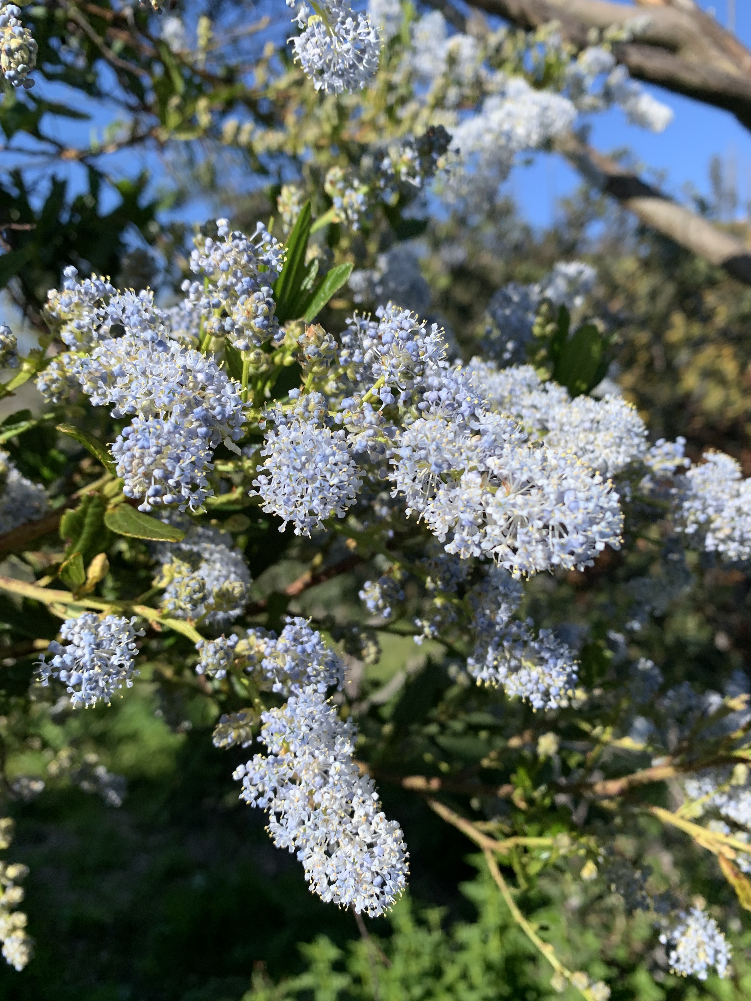
You’ll soon be familiar with one of this area’s most important native shrubs and its ecological interactions. The best poets, writers, and film makers have intimate familiarity with plants and ecosystems, enabling them to transmit their hearts and imaginations realistically. To be part of this place, to appreciate the nature around us, you might consider doing the same. Most start with the dominant trees – those are easy…aim for 10 species, and you’ll have a great start! The next step is to name and know the stories of the top 10 dominant shrubs. In this case, you’ll certainly include a shrub with a confusing array of common names: California lilac, blue blossom, wood tick bush, soap blossom, or (in yesteryear) blue myrtle (Ceanothus thyrsiflorus).
Whatever you call it, this shrub is starting to blossom right now with long fat clusters of tiny pale blue flowers, shaking with pollinators, and filling the air with incredible perfume.
Syringia vulgaris, common lilac, a denizen of gardens and native to Eastern Europe
Wild Lilac?
California lilac isn’t even closely related to the ‘normal’ lilac, but it is easily as commonly found in gardens. The European lilac is related to olives, has medium-sized leaves, and 4-petaled flowers with heady, sweet perfume. Our native wild lilac has a dusty-sweet scent, but you’ll have to squint or use a magnifying glass to see that the tiny flowers have 5 petals.
Garden Plants
There are many relatives of blue blossom, and you can even find some side-by-side in our area. My favorite is warty leaved Ceanothus, Ceanothus papillosus, which likes to grow in chaparral. This warty-leaved type has sapphire-blue flowers and a very memorable, sweet-resinous smell emanating from its leaves, especially when it is hot out. This diversity of Ceanothus types and their stunning beauty have made them very popular as garden plants. If you have well-drained soil and some space in your garden, you might consider adding one not only for their flower beauty, but for their evergreen beautiful leaves, as well as their attractiveness to wildlife. You can find forms from tight ground covers to tall and treelike with flowers from white to deep, dark blue. The flower scents are that variable, too- from very sweet to very musky.
Twenty Years Ago
Twenty years ago, it was a much more unusual treat to encounter California lilac in the natural landscape around Santa Cruz. The same can still be said of the areas that haven’t burned in anyone’s memory. Big, burly blue blossom could hardly be called a shrub back then; they seemed more like small trees, with 1’ thick, gnarly trunks and barely organized canopies festooned thickly with pale blue flowers. Those powder blue puffs stood out singly or in small groves, poking up through old manzanitas or coyotebrush, visible a half mile away for their brief flowering period and then disappearing for the remainder of the year, blending in perfectly.
And Then There Was Fire
California lilac is a pyrophile. How can life love fire, such a destructive force, cooking and searing plants and animals alike as the wind-fanned flames race across hill and valley, crackling and hissing, turning everything to smoking char? For blue blossom, there is naturally no next generation without fire and adults are lucky to live 50 years. These shrubs make a lot of seeds, which sit in the soil waiting for the winter after fire to germinate. Sleeping seeds awaken when they feel the sun and the sun-warmed soil, then seeds that have accumulated in the soil for years germinate. Carpets of blue blossom seedlings spring up, and 3 years after the fire are 6’ tall and blooming, soon raining seeds in preparation for the next fire birthing.
Getting Around
Blue blossom seeds don’t appear adapted to dispersing far from their parent shrubs. The seeds don’t have maple seed wings or dandelion fluff to disperse on the wind. And, the seeds don’t have obviously attractive fruit like acorns or avocados. But, when the seed pods explode on hot days, cracking and popping seeds loose from the mother plants, wildlife become alert to the new availability of food. Quail have been known to gobble them up, as they scratch and peck in the shrubland understory. But quail and other birds don’t digest the seeds completely: the result, perfectly viable seeds being spread across the landscape, far from mother plants.
Not Just Fire
California lilac doesn’t require fire. Any disturbance that churns up the soil and shines new sunlight onto the seeds will work just fine. So, you can find new shrubs germinating in the wake of road or trail building, logging, and even suburban gardening. There are many other sneaky species like this: ones that appear abundant after fire, almost as if they require fire to germinate. There are many fewer species that do actually require fire to germinate- many of those are triggered to sprout by chemicals leached out of charcoal in the winter rains following wildfire.
Such nice flowers on that California lilac: I wish you could smell them!
California Lilac Uses
What good is this shrub? The vigor of this species in germinating after wildfire may be important for a few reasons. First, the shrubs might help to cover and then hold soil in place after fire. Second, the species has special roots that allow it to capture atmospheric Nitrogen and make it available as a plant nutrient. Adding this fertilizer to the ecosystem may help adjacent plants to grow and recover after wildfire. Blue blossom tends to grow especially well on poor soils, so it may be assisting many other species to make it in this soil-inhospitable situation.
Moths, Butterflies and Other Insects
Besides being good bird seed, moths and butterflies depend on California lilac. Ceanothus silk moth feeds on this species (its cocoons were used ceremonially by tribal peoples); many other species of butterfly and moths likewise raise their young on blue blossom. Tortoiseshell butterflies migrate from the Sierra Nevada to raise their young on blue blossom here along the coast. Somehow, the young know how to get back to those mountains to raise their children, which in turn fly higher in the Sierra and that high-mountain-raised generation is the one that comes to the coast.
Besides the post-fire explosion of tortoiseshell butterflies, one of my favorite phenomena are the annual gatherings of what I call blue blossom dancers. Thousands of tiny beetles fly in clouds above the blossoming shrubs at sunset, their silver-shining silhouettes are fascinating to watch pulsing and undulating in their fantastic annual ritual dance. Throughout the day, you can see those dancers feasting on pollen in the flower clusters, preparing for their energetic sunset display.
Where to See Blue Blossom….and a Cleaning Trick
Head for the post-fire ecological footprint! I hear that some Big Basin trails are open as are the trails in the Fall Creek Unit of Henry Cowell State Park. Both areas have huge rafts of California lilac just starting to flower. It is worth going before the winds on a warm day to immerse yourself in the scent. Do yourself a favor and get close to the flower clusters to see the awesome diversity of pollinators. If there is water nearby, grab a big hank of flowers and get to the water. Holding the mass of flowers between your wet hands, rub them together and you can experience the sudsy nature of soap blossom. Like apricot scrub, it has just the right amount of abrasiveness to help the nicely scented suds help clean your hands.
See, you know this! Ceanothus. You are on your way.
-this post originally made available via Bruce Bratton at his BrattonOnline.com blog; check it out…weekly updates…the BEST local news source in the Monterey Bay area.
I invite you to immerse yourself for a few moments into my dream of the future of Santa Cruz’ North Coast. How will Cotoni Coast Dairies fare in the future, for instance in 2064? During the past year, many things have aligned to allow my dream to be much closer to reality.
It was 2024 and Cotoni Coast Dairies’ new manager, Zacchary Ormsby was the first with the skill, knowledge and respect to manage the property according to the Bureau of Land Management’s (BLM’s) protocol for lands with National Monument and National Conservation Lands status. Zacchary was joined by a freshly hired California Coastal Monument manager, another conservation-oriented biologist, Leisyka Parrot. Congressman Jimmy Pannetta, a skilled veteran of addressing impacts in over-loved and under-stewarded wildlands of Big Sur, has been newly elected to represent Cotoni Coast Dairies’ geography. Jimmy is dedicated to helping address North Coast tourist visitation issues with his important federal government leverage. And Justin Cummings with his doctorate in multi-disciplinary environmental problem solving was newly both the County Supervisor AND the Coastal Commissioner overseeing the park. Meanwhile, many very smart coalitions were poised to work together to assure that Cotoni Coast Dairies is a park for all, well stewarded for wildlife, forever. What a hopeful moment that was!
Looking Forward
It is 2064, the 50th anniversary of Cotoni Coast Dairies becoming public land, and there are national celebrations of this unexpectedly exemplary project. The New York Times has a full color Sunday edition article featuring the park’s success. Cotoni Coast Dairies has become a global destination for accessible, multi-cultural nature tourism. Hundreds of thousands of visitors have enjoyed immersive educational experiences that are the gold standard being copies at other parks around the world. Programs at the park have changed lives of thousands of underrepresented schoolchildren from throughout the Bay Area. Tourists of many nationalities flock to Santa Cruz with this destination in mind. The park’s managers have worked closely with scientists and conservationists, succeeding in restoring the property’s teeming wildlife populations. Visitation is so well managed that many different experiences are available, no matter what ethnicity or language and no matter the financial means. Using cutting edge technology, parks administrators provide the vast array of experiences that visitors report wanting and have developed software to continuously adapt available park experiences accordingly. BLM has received recognition for their sound management through strong public as well as private funding and through the added capacity of dedicated partner organizations and volunteers.
Badgers, Burrowing Owls, and Tule Elk, Oh My!
Early on, BLM partnered with local scientists, State and Federal wildlife agencies, and conservation groups with what turned out to be highly successful reintroduction programs for American badger, western burrowing owl, beaver, and tule elk. Volunteers working with conservation groups adapted prior regional wildlife connectivity successes to create Western North America’s first badger preserve by reintroducing ground squirrels, installing drift fences to underpasses along roads to reduce badger fatalities, and creating landscape-scale habitat corridors, and badger populations recovered. Because badgers prefer sandy soils for denning, Cotoni Coast Dairies managers designed large recreation-free buffers around the best denning sites; at first, those buffers were insufficient, but monitoring refined buffer design, and the badgers responded positively with their first young born in 2040. The badger and ground squirrel burrows created habitat that made it possible to later reintroduce burrowing owls which have established several breeding colonies in the huge swaths of restored coastal prairies. These wildlife species have become an important focus for visitation.
Restored Coastal Prairie
Besides reintroduction of these keystone grassland wildlife species, BLM managers embarked on two other processes that turned out to be critical to the restoration of some of California’s last remaining coastal prairies. First, the entire property, including its prairies, became actively cared for by the descendants of the indigenous people who have tended the landscape for thousands of years. The importance of indigenous stewardship was an insight from the outset, including in the name of the property beginning with the tribal name of the first inhabitants, ‘Cotoni.’ In the process of recognizing and revitalizing their culture, native people have directed hundreds of programs attracting thousands of volunteers, school children, and others to collaborate in the large-scale restoration of the land. They reintroduced fire management and tended wildflowers and grasses, carefully relearning the best ways to nurture them to health. The native peoples have revived their internationally renowned basketry, tending plants throughout the park for materials.
At the same time, BLM managers have used cutting-edge, science-based livestock grazing management to restore coastal prairie health. They have collaborated with many other coastal prairie managers, from Humboldt to Santa Barbara, to manage cattle alongside tule elk herds, moving the animals through a matrix of patches of grasslands managed with prescribed fire and reseeding. The prairies draw visitors each spring to view stunning spring wildflower displays unrivaled in the region.
Vibrant Lagoons and Beaches
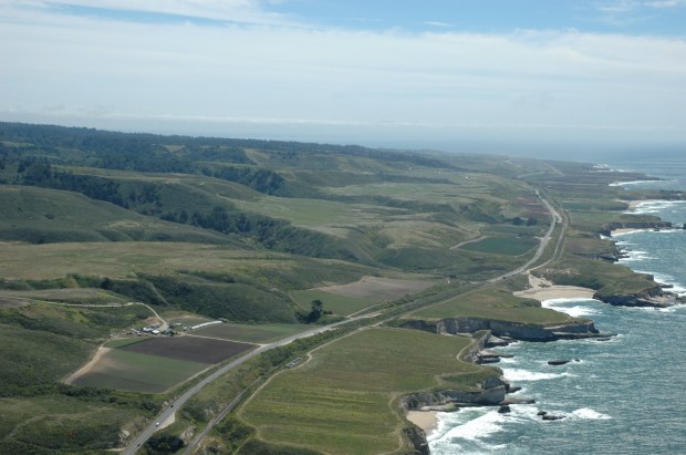
The 2050s were a decade of sea level rise adaptation made possible by the strong North Coast public lands managers partnership facilitated for decades by Santa Cruz City Parks. The first beach and Highway 1 realignment to be redesigned was at Scott Creek Beach, back in the 2030’s. Then, there were successes in restoring Lidell Creek/Bonny Doon Beach and Laguna Creek/Laguna Beach, and then the coalitions managed to redesign all the other North Coast Beaches and highway crossings. Economic development, transportation and conservation interests all converged, and every beach has moved inland of Highway 1. Multi-use bridges accommodate public transport, pedestrian, and bicycle use as well as interpretive and viewing areas which draw the highest numbers of visitors.
The redesigned bridges allowed reintroduction of beavers, which in turn restored fish habitat. Coho salmon and steelhead have been reproducing in all the newly restored streams. After 40 years, BLM wildlife biologists have succeeded in restoring California red-legged frog populations to every beaver pond and lagoon on the North Coast; this is the last place they can be reliably found, the last viable population remaining on Earth. While beachgoing recreation is no longer possible on most North Coast Beaches, the small slivers of sand now support snowy plover nests alongside elephant seal nurseries, drawing wildlife-oriented tourists to high tech, wildlife sensitive viewing opportunities.
Visitor Highlights
Cotoni Coast Dairies has become known for its approachability and accessibility. Visitors are greeted by guides who can communicate in 14 languages; interpretive information on interactive signs is available in an additional 30 languages. Guides are provided state of the art, sustainably constructed family homes attached to visitor interpretation outposts spread throughout the property, allowing 24-7 oversight.
Visitor experiences at Cotoni Coast Dairies vary with time in response to ongoing surveys of existing and potential users. While it has become necessary to limit use, a universally available reservation system assures fair distribution of tickets. Free transportation into the park is available from nearby public transit hubs. The reservation system allows park managers to adjust amount and types of use, including segregating users within the park, to accommodate visitor expectations and reduce use conflict. Families feel safe walking small children or elderly family members on tranquil trails while thrill seeking bicycle riders enjoy uncrowded downhill forays without worrying about others’ safety. If you don’t mind more crowded conditions, you won’t be surprised by what you experience. But, if you want more solitude or better wildlife viewing opportunities, parks managers have specific days, trails and destinations just for you.
One of the most popular reservation requests is for guided nighttime wildlife viewing. For this opportunity, small groups are guided into one of 10 remote viewing locations designed to minimize wildlife impacts while maximizing the opportunity to view nighttime wildlife using the latest night vision technology. Visitors enjoy these immersive experiences, with interpretation and storytelling by expert volunteer naturalists.
Digital communication has allowed active feedback about visitors’ experiences to parks managers, and data feeds into the network of universities participating in the studies and assisting with adaptive management. Management response to real time social carrying capacity analysis has become second nature to Cotoni Coast Dairies users and the vastly superior visitor use experience has resulted in a high demand for updating other park system management protocol.
Realizing the Dream
What I describe above is truly attainable if we want it bad enough and are willing to act. The key element of success is public will which is necessary to raise our capacity to succeed. We’ll need leadership, volunteers, capital, technology, and kindness. And, we need to have a common vision: I hope I began that by communicating something we can work together to hone and then aspire to. If you like this vision, let BLM, Jimmy Panetta, and Justin Cummings know by clicking those links and writing a short note referencing this essay.
-this post originally posted via Bruce Bratton on his vastly illuminating weekly blog at BrattonOnline.com: subscribe now and SAVE!
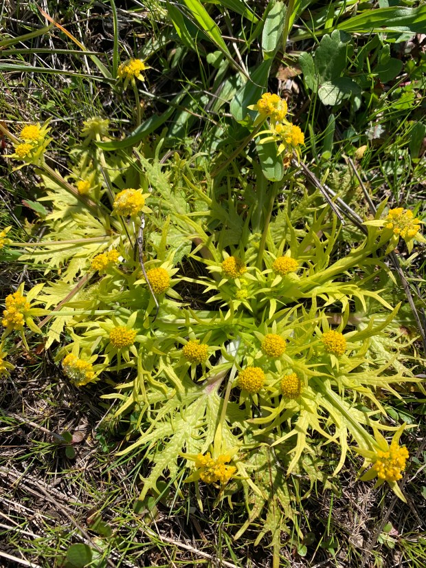
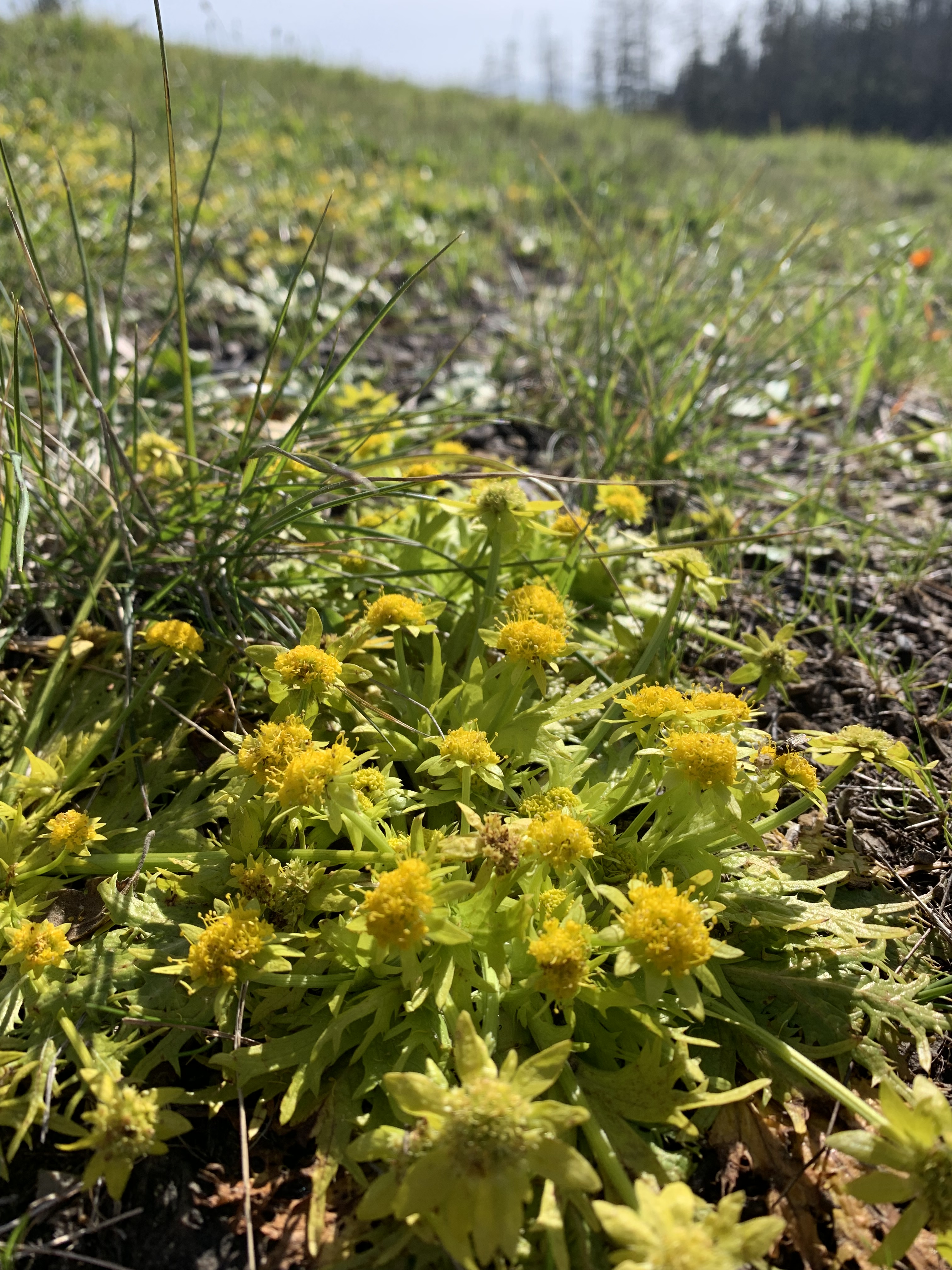
Another in my monthly series challenging readers to stay in touch with the seasons by locating one of the quintessential plants flowering at this moment in Central California. This month’s (March’s) flower: footsteps of spring.
Bare Foot Healthy
Botanists have a history of assigning ironic, sometimes deeply ironic, Latin names to plants. This one’s Latin name is Sanicula arctopoides. Some suggest that going barefoot is good for your health, others suggest caution. This plant’s Latin name does nothing to settle that score. The first name comes from the Latin “Sanus” meaning ‘healthy’ (sanitary, for instance) and its second name is a play on words: “arcto” means ‘bear’ and “poides” refers to ‘foot:’ put the two together and you start sensing the wordplay – “bear foot.” In full, the name means bear foot healthy. I’m not suggesting that the Latin name refers to the horrible and unsupported consumption of bear’s feet for health benefits. Rather, I suppose it was meant to be a twist on words. There has long been controversy over whether or not going bare foot makes for better health. I’ve had hippy friends swear to the benefits of going barefoot – I tried it myself for quite a long time with mixed results. I spent a semester of my undergraduate time in a Costa Rican cloud forest, during which I mostly went bare foot as my shoes otherwise never seemed to dry out. This led to a memorable experience where an itchy blister turned out to be full of maggots, an infection of tropical foot-burrowing flea larvae. That experience was kind of the opposite of this plant’s Latin name translation, “healthy bear (bare) foot.” But, I digress…
Magical Tracks
If there was a magical grassland Sprite calling up the advancing Spring across our meadows, she might dance from one ridge to the next, leaving her first footprints in the form of this gorgeous plant, subsequent waves of other wildflowers and color emanating from her earlier footfalls.
Yellow-Splashed Rocks
Footsteps of spring plants are the brightest of yellow, but it’s not just the flowers. As the plant starts to make flower clusters, the leaves surrounding the flowers emerge as pale, bright lemon yellow framing the likewise pale yellow flower clusters. The entire plant frames and highlights globe-like clusters of tiny flowers. This species is low-growing – ground-hugging even – and can’t take light competition from surrounding taller plants. And so, patches of footsteps of spring are found on rocky ridge tops or rocky-shelved outcrops especially where the surrounding vegetation consists of grassland species and where soil conditions aren’t conducive to taller, shading, more productive plants.
Smells Like…
I don’t want to prejudice your sniffer, but I am hoping to hear from people about what scent they get from the flowers of this plant. Also, the leaves of the close relatives of this plant normally have interesting odors…one species releases an uncannily cilantro-like scent, for instance.
Whatever scents this wildflower emits, the only types of pollinators I’ve seen visiting the flowers are different types of flies. Maybe the presence of flies as pollinators hints at the scent of the flowers…
-this essay originally published by Bruce Bratton at his weekly blog BrattonOnline.com
Someone new on the scene recently asked me to explain the history of what went wrong at Cotoni Coast Dairies. After many, many years, the property still isn’t being managed for wildlife or public safety, and it still isn’t open to the public. As a prelude to this, I urge readers to read my essay on how the Bureau of Land Management (BLM) came to manage the property in the first place…a curious story, indeed. This essay compliments that prior essay with more details, especially since BLM took over managing the property. Soon, I’ll be writing the third in this series with suggestions about what is needed to improve this unfortunate situation.
Years of On the Ground Nothing, or Worse
Since its purchase for conservation, Cotoni Coast Dairies has a history of very little stewardship and management. Trust for Public Land purchased the property in 1998 and held it until 2014. During that time, managers working for the Trust for Public Land did almost nothing to maintain the property. Occasionally, someone would show up to clear some anticipated future trail. For instance, TPL contractors extensively cleared riparian vegetation along Liddell Creek, chainsawing decades-old willow trees that shaded endangered fish habitat and provided cover for the endangered California red-legged frog. They argued that the clearance was along an ‘existing road,’ and they started putting this trail on early maps as a favored future public access point. (The trail later appeared on BLM’s maps, but federal wildlife protection agency personnel demanded otherwise, so the trail disappeared from plans.) Otherwise, TPL let fences, gates, and culverts rust away, roads and trails erode, weeds spread, and fuels build up creating hazardous conditions for future wildfires.
In 2014, BLM took over management of Cotoni Coast Dairies, and those same patterns largely continued. Early on, BLM staff constructed a new trail, carving through nests of state-listed sensitive wildlife without required State consultation. Like TPL, BLM staff have either overlooked erosion issues along roads or graded long abandoned ‘existing roads’ (aka ‘future trails’) with uncannily similar detrimental impacts to rare fish and amphibians. Meanwhile, terrible weeds and immense wildfire risks continued to spread across the property. The reason BLM staff have given for such poor stewardship: ‘we don’t have an approved plan.’ That changed, but management hasn’t…except for one new stretch of cattle fence and subset of future trails being created mainly by volunteers. The trails and fence came before any work on invasive species or wildfire mitigation, so we sadly sense BLM staff priorities have been directed away from conservation towards recreational access.
Decades of Funky Planning and Community Engagement
Staff from both TPL and BLM have sporadically spent a bit of time working on poor planning processes or participating in largely perfunctory public meetings about property management at Cotoni Coast Dairies. In the year 2000, TPL convened and facilitated a Community Advisory Group (CAG) to advise on guidelines meant to be used by future managers. A few of us on the CAG were asked to provide feedback about the biological portion of those guidelines, but we were unable to improve the largely cursory and incomplete biological assessments used to guide future property management. It is unclear if those guidelines have ever been used by BLM, or if TPL even cares.
BLM has done little to inventory the property, so it has very poor information with which to plan its management. And so, BLM’s plans have overlooked species and ecosystems that are easily identified and/or previously catalogued by reputable sources. This alienates the conservation community including the wealth of well-trained scientists that this region enjoys.
Instead of the long series of TPL’s CAG meetings, BLM staff have appeared for a very few community-engagement-style meetings, including one early on that was convened and facilitated by the Land Trust of Santa Cruz County. That Land Trust meeting surprisingly and very oddly focused on weighing pros and cons of parking lot locations, but it was never clear why public input was sought or what became of it afterwards. In the midst of this, an outside funder parachuted in hundreds of thousands of dollars so that several local organizations could mount a seemingly ‘grassroots’ Monument Campaign.
Monument Ahoy
In 2015, The Sempervirens Fund led the “Monument Campaign,” a fast-paced, highly scripted, well-funded effort to organize rallies and letter writing to show public support for National Monument designation of Cotoni Coast Dairies. In what is increasingly common “fake news,” the bulk of the Monument Campaign messaging was about opening the property for public use, while in fact Monument designation is more about improving conservation of the property…which would typically increase limitations on public access. This nonsense was compounded by campaign organizers’ refusal to address how designation would increase deed restriction protections already in place from TPL. Furthermore, organizers dismissed concerns about managing the anticipated influx of visitors drawn to something called a National Monument. How important the Monument Campaign was in Obama’s designation is unclear, but the divisions in the community were deep and lasting. Organizers were successful in coalescing well-meaning but very poorly informed people whose nonsensical byline was “Monument designation means my family will be able to visit!” On the other hand, there was a surprisingly politically diverse coalition equipped with well-informed questions and concerns that were never addressed. After that local experience, it is difficult for me to believe that any political faction is immune from using scripted ‘truthiness,’ hype, or even lies when they feel those tools necessary in attracting popular support for secret agendas. Unsurprisingly, leaders of the ephemeral Monument Campaign movement have since disappeared from involvement, leaving the aftermath for the real, long-term grassroots organizations to deal with, and we have yet to experience any conservation benefit of Monument designation.
Pop Up Trail Plans, Abandoned
As the Monument Campaign launched in 2015, BLM issued a proposal for the property’s first public access trail, aka the “Laguna Trail,” in an expedited environmental review process that showed our community how poorly equipped BLM staff were to adequately plan for the property. BLM staff relied on old, insufficient biological inventories for their analysis, failed to survey for endangered species, and did not include any analysis of how the trail would address social equity concerns in providing for visitor use. BLM staff did not respond to the many concerns raised by the public but instead completed their pro-forma circulation and approval of planning documents and rapidly deployed machinery and workers to clear the trail. Trail construction proceeded without conforming to even the nominal environmental guidelines outlined in BLM’s planning documents. The hastily constructed trail cut through state-protected wildlife habitat, degraded historical artifacts, and came very close to a native village site which BLM failed to plan for protecting. In addition, if the project had proceeded, BLM would have opened a trail beginning at Laguna Creek Road and Highway 1 without any new parking, litter, or bathroom facilities, without sufficient staffing for enforcement or interpretation, and without a recreational plan for the property as a whole to analyze how to best protect wildlife while providing public access. This pop up trail was BLM’s way of introducing themselves to the land and to our community.
Introductions to BLM Planning Procedures
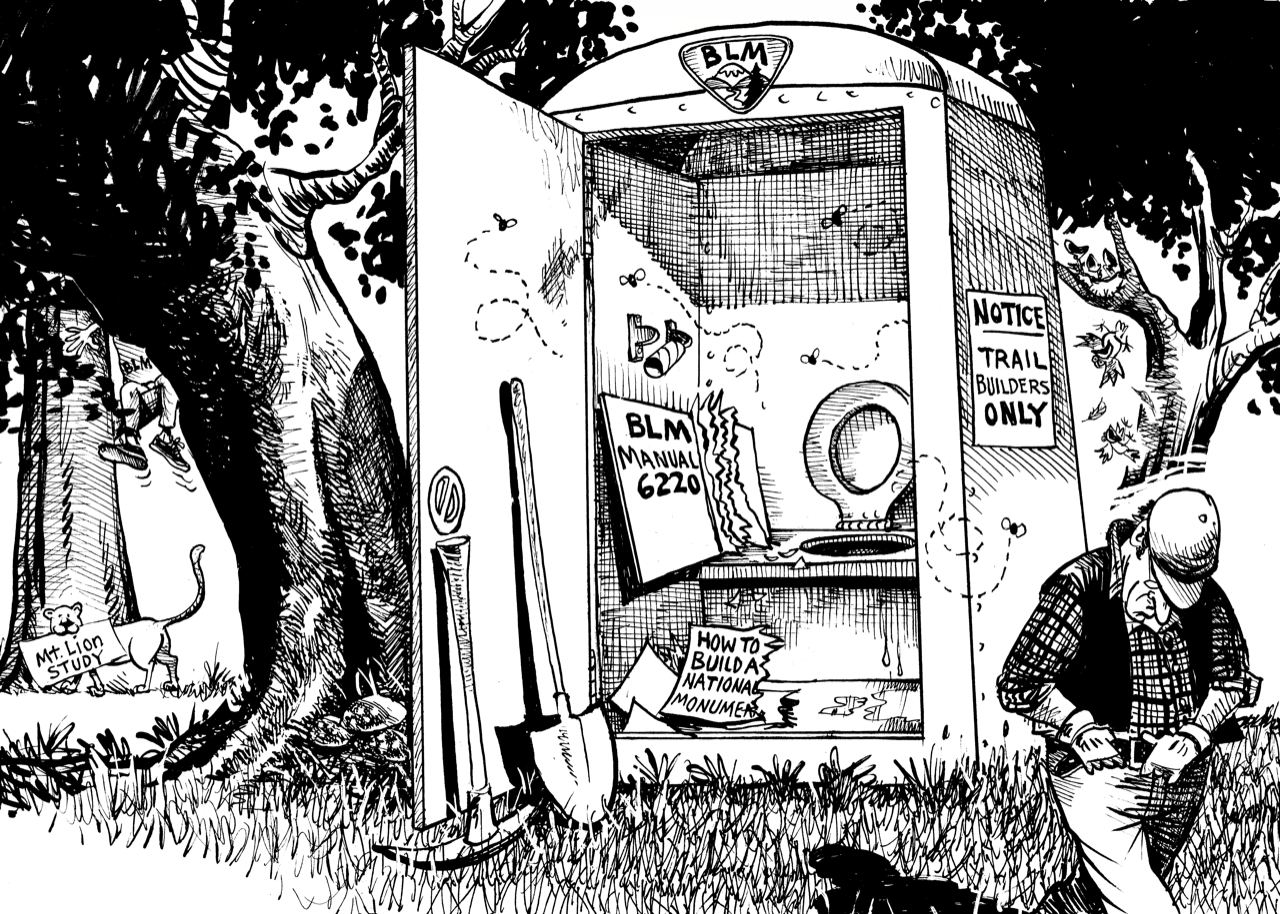
As the first federal land manager in the County, it was BLM staff who introduced our community to the federal government’s environmental planning process. This introduction was surprising in many ways. We had been accustomed to public lands managers paying careful attention to protecting “environmentally sensitive habitat areas” (ESHA) according to Coastal Commission rules. Not so with this property – BLM staff didn’t even provide the public maps of those regulated habitat areas in any of their planning documents! With the promise of National Monument protections, we were hopeful that BLM staff would follow the required and highly regimented process outlined in BLM’s policy “Manual 6220,” which provides staff with guidelines on how to manage national monuments. Again, not so! In fact, BLM staff have not used the 6220 manual and have neglected any public acknowledgement of the manual, as if they do not intend to use it, at all. Moreover, BLM staff have never specifically acknowledged the many species and ecosystems protected through the monument designation process. Monument management protocol seems irrelevant to BLM staff, who are apparently bent on expediting the public access so vocally anticipated by the Monument Campaign (coincidence?).
The job ain’t finished until the paperwork is done! Cartoon compliments of DeCinzo, Caption by Grey Hayes
Expediting Public Access
BLM staff have chosen expediency over thoroughness in each of their property planning exercises. For their most recent property-wide plan, instead of data-based predictions of visitor use, BLM staff chose a largely arbitrary low-ball figure of 250,000 anticipated visitors/year for the property. Instead of the logical in-depth alternatives analysis of a full Environmental Impact Statement (EIS), BLM staff have chosen expedited Environmental Analysis (EA) processes, complete with incredible conclusions of ‘Finding of No Significant Impact (FONSI),’ despite significant contrary expert testimony that has gone unaddressed and unacknowledged. As we learned for the first time about its ‘federal consistency process,’ the Coastal Commission recently mandated that BLM use a phased approach to opening the property to public use. The Coastal Commission required that only if/when the BLM proved it could adequately manage public use could it open the full range of parking lots and trails; that proof requires monitoring and such monitoring would normally require a baseline inventory of sensitive natural resources, but we have yet to see that happen…we don’t even know the language to which the BLM and the Coastal Commission have agreed.
Nipping at the Community
My personal interactions with BLM staff have historically been less than pleasant, perhaps because those staff members are unused to much public engagement. My experience of poor interactions with BLM staff isn’t isolated. Someone suggested that this might be partly because those staff feel ‘rocked back on their heels’ because of criticism of their work, which is odd because our comments have been professional, polite, and part of what BLM should expect as public lands planning processes. A BLM staffer told me long ago that their colleagues were in for a surprise as they encountered the very actively involved communities of Santa Cruz County’s North Coast. Previously, most BLM staff working at Cotoni Coast Dairies had worked very much out of the public eye, in remote parts of California with little/no public oversight.
While we can’t ascertain why BLM staff have avoided offers for assistance, their subterfuge is as enlightening as it has been damaging. My compassion about staff feeling rocked back on their heels is limited because BLM staff have sought to discredit my work and harm my reputation, even approaching employers with false information to negatively affect my job while also giving ultimatums to conservation networks to preclude my participation. During one encounter at a public meeting, a BLM staff person told me that they would never collaborate with me or the groups with whom I worked because I was “against any public access at Cotoni Coast Dairies.” That was an incorrect statement about my position that I had likewise been hearing from a particularly activist, radical group of mountain bikers. As this BLM staff person echoed that quote, it was possible to better understand communication channels and allegiances.
My earliest interactions with BLM staff at Cotoni Coast Dairies were when I proposed assistance for biological monitoring. I and a few other biologists offered BLM free assistance with biological surveys to improve their understanding of the property. After that proposal, over a very long time, a BLM staff person strung us along through an incorrect informal process without ever encouraging us or acknowledging the potential value of such work. There was a chain of calls and emails that each ended with something like ‘well, maybe….’ By the time we subsequently discovered the correct application process and applied in that way, leadership had changed and the application was then officially refused.
Cumulative Impacts: Traffic, Trauma, Toilets and Trash (the 4 T’s)
It is important to view BLM’s problems in the context of issues related to visitor access on conservation lands throughout Santa Cruz County. As with all of the other public lands managers, BLM has been planning for visitor use and conservation in a vacuum, as if the surrounding lands don’t exist: this is a deeply flawed perspective. Much of the land from Santa Cruz City to the County line is heavily used by recreational visitors. Most weekends, parking lots overflow with cars and parked cars dangerously line the highway. There are too few trash cans and toilets to serve those visitors. Police and emergency responders are stretched to respond to the many accidents such visitation is bound to create.
County Parks, State Parks, the City of Santa Cruz, the Rail Trail, and BLM each have their own properties to manage and the same 4 T’s issues to address, but they aren’t doing it collaboratively. It is clear that none of those agencies has the resources to address those issues and so those issues are borne by our community. Visitors have come to expect trashy beaches. Emergency responders have come to expect exhaustion and insufficient support. Visitors with elderly family members or small children are avoiding parks due to dangerous or disgusting conditions. As each agency plans in isolation to provide for the maximum number of visitors, parks managers are dooming wildlife and visitor experience – the carrying capacity for the entire North Coast will be surpassed. It is no wonder that our community does not trust BLM to be able to manage their land and the visitors that they plan on attracting. BLM entered an arena of mistrust and fueled the fire with their own mistakes.
Who is Responsible?
Those of you who know me well know I don’t like the passive tense: I like clearly stating the subjects of verbs…who (specifically) is responsible for doing what (specifically). And yet, agencies like BLM are opaque…staff even refuse to specify who is specifically responsible for anything you might witness happening. But, placing the entire blame of the tragedy of Cotoni Coast Dairies on current BLM staff is unfair. Local, state and federal elected officials also bear some responsibility; good intel is that some of them have even winked behind closed doors in Washington DC, saying that local concerns needn’t be addressed. But again, placing a large amount of blame on elected officials also doesn’t seem fair: after all, they should be swayed by popular opinion (or at least election).
We saw how enough funding swayed popular opinion with the Monument Campaign, right? Apparently, no funders have been inspired to sway popular opinion in favor of wildlife protection on conservation lands in this particularly biodiverse region. Even if they did, there is a dearth of organizations who would lead that campaign. And so, in regard to the tragedies unfolding at Cotoni Coast Dairies and across Santa Cruz County’s North Coast, we must bear the brunt of blame within our community, which has long lacked leadership, energy, and focus on environmental conservation. For more on that, read my essay “Democracy and the Environment.” And, stay tuned for the third in this series of essays where I will outline steps forward out of this unfortunate predicament.
-this article adapted and updated from what appeared in late March at Bruce Bratton’s blog BrattonOnline.com
Monterey pine (Pinus radiata) is an extraordinarily valuable endangered species that has received insufficient conservation recognition. The stand of pines around Año Nuevo have been heavily impacted by wildfire but are regenerating well (for now). Meanwhile, much of the Monterey pine stand on the Monterey Peninsula is effectively gone. Cambria’s Monterey pine forest has likewise been compromised. In both cases, while there is what appears to be Monterey pine forest in and among homes, those trees are what are termed ‘relictual’ – without fire, they will not regenerate and no one is suggesting that prescribed fire be used in neighborhoods to manage those forests to perpetuate them as they would naturally need to be. In an ideal world, homeowners in Cambria and on the Monterey Peninsula would be so interested in conservation that they would participate in an expensive program to replant older pines with enough genetically appropriate seedlings as to maintain those populations, but we have too little leadership, interest, and funding to support that kind of initiative. My hope is this becomes a reality. The first step is to build awareness and interest. Your job is to help tell this story to increase support for the protection of this pine. The next step is to gain State legal protection of this endangered species.
Timber Importance
Monterey pine is an enormously important tree for producing timber around the globe. Some of my advisors suggest I start any argument for conservation in the economic realm, and so I start here. If you are going to discuss this tree in this context, the first thing you need to do is to use the correct terminology, starting with the right name for the tree. Call the timber tree ‘radiata pine.’ That’s because it has been so intensively bred as to be easily distinguished from its wild counterpart.
10 million acres of radiata pine occur in timber plantations, mostly in Australia, New Zealand, Spain, and Chile.
As the effects of climate change intensify, it will become increasingly important to maintain and adapt the genetics of radiata pine. While there is some genetic diversity already embedded in plantation radiata pines, there will inevitably be a need for wild genes to augment the plantation trees. And so, conservation of the wild populations becomes important even to the timber industry. Because the wild populations are distant enough from each other, each population has unique attributes that would be important for the health of radiata pine for future timber production.
The Five Pine Populations
There are five wild Monterey Pine stands, three in California and two in Baja, Mexico: Año Nuevo, Monterey, Cambria, Cedros Island, and Guadalupe Island. The Año Nuevo stand is the largest, growing from southern San Mateo County in the north to near Bonny Doon Road in the south. The Monterey stand is bounded to the north by Highway 68 and then into the northern Big Sur to the south. The Monterey stand occupies a series of ancient marine terraces, each with very different soils, an ‘ecological staircase’ with each terrace supporting very different biotic communities. As you move up the staircase, the pines become increasingly short-statured due to age of the soils increasing and, therefore, the soil fertility decreasing.
The population in and around the town of Cambria. There are also two very odd populations on islands to the west of Baja California. Cedros Island is 14 miles offshore of central Baja and Guadalupe Island is 130 miles offshore of northern Baja Mexico. The Guadalupe Island population has historically been highly threatened by goat grazing, but goats have been recently controlled and now there is hope. The Cedros Island population fares better. The two Baja populations of Monterey pine stand out in having only 2 needles per bundle as opposed to the 3-needle bundles from the other populations.
Local Importance, Local Threats
Superficial consideration might suggest that Santa Cruz County’s Año Nuevo stand of Monterey pine is well protected, but there are important issues to consider which might lead to different conclusions. This stand of endangered pines is the largest and much of it is located on property where the owners are amenable to good stewardship. And, this stand is also likely the origin of the plantation ‘radiata pine,’ and so contains the historical suite of genes that have been so important to forestry. This location is the only one where Monterey pine hybridizes with another species – knobcone pine. Sometimes, people refer to ‘hybrid vigor,’ and breeders once saw that expressed from trees grown from Año Nuevo stock in their trials as they selected the best trees for plantations.
Although the Año Nuevo stand has strong potential for conservation, there is no plan to guide that conservation and no leadership in convening and focusing that stewardship. An invasive pathogen, pine pitch canker, has the potential to continue spreading, killing up to 80% of the trees. Other pathogens will no doubt be introduced due to carelessness in regulating global trade; those pathogens will likely be spread along recreational trails and roads through the population. There is also the issue of fire…
The 2020 CZU Lightning Complex Fire raged through most of that population spurring (in patches) a whole new generation of trees. How frequently will the stand burn is an important question – too frequently and the pine may be unable to persist for many more generations.
Fire Adaptation
For millions of years, the distribution and health of Monterey pine has been shaped in a dance between fire and fog. Not too long ago, Monterey pine circled the Monterey Bay, but it has persisted only in the foggiest and most fire-free areas. With climate change, wildfire is expected to increase in frequency and intensity. The 2020 fire left large numbers of dead pines and other trees standing; those present a massive fuel load for subsequent fire(s). With so much fuel loading and anticipated increased fire frequency, I am concerned that fires will become too frequent and intense for adequate regeneration of Monterey pines. For those of you who want to view a now very rare healthy and diverse Monterey pine forest, I strongly recommend that you visit the very few remaining areas very soon.
Where to Go
While it will be instructive to see how Monterey pines are regenerating from fire at the Año Nuevo stand, it is perhaps more enjoyable to see mature stands near Monterey. Within the Año Nuevo stand, you can see post fire regeneration by gazing into the forest along Highway 1 at Waddell Creek beach. If/when BLM opens its northern trails at the Cotoni Coast Dairies, visitors will be able to glance one of the southern-most patches of the Año Nuevo stand of Monterey pine is on a hillock above those trails. Near Monterey, the Huckleberry Hill nature preserve is worth seeing as is Point Lobos State Park and Jack’s Peak park.
What You Can Do
In 1999, the California Native Plant Society petitioned the State of California to list the species as Threatened; the State however refused to consider the petition due to lack of staff resources/time/money to adequately process the petition. This example joins a plethora of other similar situations: the State of California needs citizen support to allocate the necessary funding to list deserving species as Threatened or Endangered so that they will be adequately protected at the local level. We should all be writing to the California governor and our local state assembly and senator members to ask for increased budget and attention to promulgating and analyzing listing petitions for species including the Monterey pine. Here are the contact emails: Governor Newsom, Senator Laird, and North County Assemblymember Gail Pellerin or South County Assemblymember Robert Rivas.
-this article orginally published in my weekly column at BrattonOnline.com, where Bruce Bratton’s team updates our community about local issues from experts who tirelessly track such things. Thanks Bruce!
I like the phrase ‘all politics is local’ and have coined a corollary phrase ‘war starts at home.’ We must find solutions that work at the local level, including resolving conflict. My twist on these issues has an environmental focus, and I want to illustrate our local situation in this essay.
Voting
If locals were judged for those they elect, how environmentally-minded would anyone think we are? I can’t think of a single local city council member who purports to prioritize environmental conservation. None of our County Supervisors advertises environmental conservation as a primary concern. Likewise, the local State Assembly members do not have strong environmental conservation platforms. Only when you reach the level of State Senator do we get an inkling that our local constituencies support environmental conservation: John Laird has long been an effective environmental conservationist, and conservation is one of his main priorities.
As we consider voting, how are we to be informed about which candidate might best serve environmental conservation? My experience has been that it is not easy. Unfortunately, there is no reliable environmental conservation organization informing local votes through their endorsement process. The Santa Cruz Group of the Ventana Chapter of the Sierra Club used to serve this important role, and the Group still ostensibly considers making endorsements – apparently only if a candidate seeks their endorsement. For 2022, the Group posted a list of endorsements, though without any analysis explaining their reasoning. Upon examination, most of the candidates they endorsed had little or no mention of environmental conservation in any of their election materials.
Lacking other means, you must follow environmental issues yourself and watch how politicians and political candidates react to those issues. Even if you track a single issue, you will find it helpful in illuminating for whom you should cast your vote. As a reminder from my past columns, priority environmental conservation issues for our area include: habitat protection for maritime chaparral and coastal prairies, creek and river habitat conservation, water pollution, and wildlife habitat connectivity/corridors. Of course, there are many issues to address when conserving rare and endangered species throughout our region, and those must be prioritized as well. If one of those priorities strikes your fancy, watch it carefully to see who is active and how politicians navigate to address them…and vote accordingly.
Environmental Advisors for Politicians
One of the ways environmental conservation conflicts might get resolved is through governmental advisory bodies. Locally, cities and the County have advisory bodies that ostensibly COULD advise on environmental matters. However, I cannot think of a time when City Council Members or County Supervisors sought out those advisory committees for advice, let alone acted on any of the advice otherwise offered by those committees. I suppose that’s a reflection of politicians’ assessment of how much local voters care about environmental matters. You might ask yourself, ‘are there environmental conservation conflicts locally?’ I hope you recognize that the answer is, ‘yes.’ The next question is ‘how are those conflicts being addressed?’ The answer is, ‘they are not.’ ‘Why?’ The answer to that question is ‘one side, the one in power…the one that destroys the environment…is winning.’ Why would anyone seek to resolve conflict when they are already winning? Two reasons come to mind: the primacy of environmental conservation for life on Earth and, consequently, avoidance of war which is the natural result of the degradation of the environment. All politics is local, and we’ve punted on this issue to our peril.
The following section lists the advisory groups that could be tasked to help resolve environmental conflicts, should politicians ever realize the importance of doing so.
City of Santa Cruz
The Santa Cruz City Council has a Parks and Recreation Commission to advise the City Council. Unfortunately, as reflects the views of the politicians who appointed them, the majority of those advisors care so little for environmental conservation that they fail to address those issues as part of their advisory role. This is a shame because the City’s parks contain a wealth of biological diversity, including many rare and endangered species, and these advisors could be valuable in helping to address most of the priorities I outlined above.
County Political Advisors
The County curiously has two bodies to advise the Supervisors about environmental matters: the Fish and Wildlife Advisory Commission and the Commission on the Environment. The Fish and Wildlife Advisory Commission membership historically has included a majority of experts with strong environmental conservation track records. After years of that Commission, there was the anomalous creation of a second advisory body, the Commission on the Environment – this one appointed with a majority of members without any environmental conservation interest, expertise, or experience. If you’ve got insight into why that second commission was convened when Supervisors could easily turn to the first, I’d love to hear from you.
Each of the groups above has a history of success in their own issue areas in our region. But, even with all of their work, major environmental crises still plague our area and are going virtually unaddressed. Those crises are getting worse. And, despite the work of all of these groups, we have the bleak political landscape that I outlined in the opening of this piece. Simply put, none of those groups has affected the political change we need to sustain environmental conservation in our region.
Rating Activist Groups
If we want to donate money or join a group, how do we know how effective it is? Unfortunately, there isn’t an organization that rates our local conservation groups for their effectiveness. Nationally, if you want to give money to a group for environmental conservation, you might use Charity Navigator to peruse groups’ effectiveness. But that group’s ratings don’t really reflect our local situation. For instance, if you looked at the Sierra Club, you might find Charity Navigator’s high rating for the Sierra Club Foundation, whose work (despite the nomenclatural similarity with the Sierra Club Santa Cruz Group) doesn’t address our local conservation issues. Here again, if you follow even a single local issue, chances are that you’ll get to witness the effectiveness of a local conservation group. I know the groups I’ve been impressed with…but, we have so much more to do!
Working Together to Healthy Nature and a Lasting Peace
Only by working together, through democratic institutions and processes, by supporting the leaders and groups that are most effective, can we create the local changes from which others can learn. Together, starting locally, we will create a world that embraces successful environmental conservation and achieves a lasting peace. I hope that you will do something to help.
-this post originally published at BrattonOnline.com, a dependable source of interesting information especially for the Monterey Bay area. Sign up and enjoy.
When you visit conservation lands, how do you think critically about stewardship? There are various things to consider and ways you might help.
The Balance
Often conservation lands managers mention their obligation to balance conservation with public access. In our area, this is especially true for State Parks and the Bureau of Land Management (BLM). Here are some Mission Statements to help you understand:
State Parks Mission: “To provide for the health, inspiration and education of the people of California by helping to preserve the state’s extraordinary biological diversity, protecting its most valued natural and cultural resources, and creating opportunities for high-quality outdoor recreation.”
BLM’s mission is “to sustain the health, diversity, and productivity of America’s public lands for the use and enjoyment of present and future generations.”
The normal thing to do when analyzing how to provide a balance between recreational access and conservation is to perform a carrying capacity analysis, which defines ‘limits of acceptable change.’ Monitoring determines if limits are surpassed, and adaptive management reacts with changes to public access patterns to address any problems. If the carrying capacity analysis process were integrated into a collaborative natural resource management program that welcomed public participation, controversies about changing and limiting public access could be managed with more understanding and cooperation.
Visitor Use Expectations
If they followed state of the art management practices, conservation lands managers would consistently determine what prospective visitors expected and adjust to meet those expectations. Expectations are monitored through interviews and surveys not only of people actually visiting the conservation area, but also prospective visitors in the general population. Managers normally encounter a great deal of diversity of expectations from conservation lands visitors. Some want active recreational experiences – trails/roads to jog along or mountain bike; some mountain bikers even want “rad” experiences involving tricky terrain to navigate at high speed on single track trails. Other visitors hope for quiet, contemplative strolls, opportunities to observe wildlife, or safe places to walk with elderly or very young family members. Still other portions of the population want to recreate on motorized vehicles, fly kites or drones, or rock out with parties involving amplified music and dancing. And, other segments of the population want places to meditate, collect medicinal herbs or edible mushrooms, help with stewardship, or take photographs. Obviously, it is impossible to provide everything to all people on any given parcel of conservation land, but how can managers decide what to do?
Meeting Whose Expectations?
Conservation lands proponents are sensitive about meeting many different expectations because they perceive benefits of increasing the public’s support of conservation lands acquisition, which is expensive. Sometimes this is complicated because lobbyists for various recreationally-oriented businesses are good at amplifying their client’s voices to advocate for specific types of visitor use. Traditionally, hunter groups and off highway vehicle organizations achieved successes this way. More recently, mountain biking organizations have been similarly influencing conservation lands management. Proponents of conservation lands acquisition dodge the tricky nature of favoring some types of visitors over others by public cheerleading for ‘maximum public access’ while privately providing pressure for a small subset of visitors, usually those they think are most politically influential. This is why State Parks managers opened Wilder Ranch hiking trails to mountain biking without any analysis or planning, welcomed the public onto the Coast Dairies’ beaches without environmental review, and allowed a private organization to operate a parking lot, gift shop, and privately controlled entrance to Castle Rock State Park. This is also why the Bureau of Land Management will soon allow e-bikes to use trails at Cotoni Coast Dairies. BLM is also planning on crowding all visitors onto trails that will be so heavily used as to spurn contemplative users while disturbing wildlife enough to alienate bird watchers. Families will have their hopes dashed of viewing sensitive wildlife such as bobcats, badgers, and foxes, species that frequent the property before the public has been admitted.
Coastal Commission Cahoots
I would be remiss if I didn’t remind readers that the much-lauded California Coastal Commission has been a close party to such poor ‘maximize public access’ decisions. Politicians have long appointed Coastal Commissioners who agree to the (bogus) ‘maximize public access’ mantra and who consequently believe that protecting nature gets in the way of their political success. Likewise, staff who support this schtick are empowered and promoted…and an organizational culture has been created that knows little else. And so, our beaches, bluffs, and coastal parks are being overrun by visitors, vegetation trampled, hillsides eroding, and wildlife quickly disappearing.
Quality Experience
In our rush to maximize public access, we are losing the quality of visitor experience. Social scientists have long understood that conservation lands visitor expectations can erode based on what is “normal” to experience. As levels of trash increase, people expect trash…and become more careless about leaving trash in natural areas. With poor planning, parks become more crowded, and people lose expectation of contemplative experiences, nature becomes less healing. As over-used, badly managed trails erode into ditches with holes, elderly people stop visiting their favorite places; the average age of visitors grows younger and younger. As poorly educated conservationists work together for the ‘maximum use’ paradigm, families stop expecting to teach their children about wildlife from first-hand observation and the conservation movement loses wildlife advocates.
Oh, But Funding!
Enter into conversation with conservation lands managers with these critiques and the conversation quickly turns to lack of funding as the excuse. ‘We just don’t have the funding to….’ While I am compassionate to lands managers that they face a very dire funding situation, I posit that such poor funding is a result of bad decisions by individuals within their organization and lack of enlightened leadership in the conservation community.
When you hear complaints about funding, I encourage you to ask some follow up questions, like: ‘Have you completed “Carrying Capacity Analyses?”’ ‘Have you delineated “Limits of Acceptable Change?”’ ‘What has your monitoring revealed about the trends of sensitive plant and animal populations on your land?’ ‘How have you managed for changing visitor use and visitor expectations over time?’ If conservation lands managers prioritized addressing those questions in collaboration with the conservation community and the public at large, funding would be less of an issue. When visitor use is curtailed within the collaborative and adaptive management context, there is increased political support and funding for stewardship, planning, and improved alternatives that better address visitor expectations.
What You Can Do
See something, say something. I encourage everyone to speak up and vote for these issues. Any politician at any level must interact with these issues in some way: they should have clearly stated policies that they support to improve conservation lands management. And, they should know the term ‘carrying capacity analysis’ and support the practice as it relates to conservation lands management.
And, if your expectations are not met when you visit conservation lands, you should let the managers know. Are the trails in good shape? Did you see wildlife? Was it too crowded? Did you feel comfortable with the other kinds of users on the same trails? Was there trash? Were bathrooms adequate? Did you and your family feel safe?
Finally, ask conservation lands managers the questions posed above. Also, ask how you might help to manage and monitor within their defined carrying capacity, or how you might then advocate for increased funding for their adaptive management. These dialogues could help immensely.
-this article originally published by Bruce Bratton at his weekly BrattonOnline.com, an invaluable piece of journalism helping thousands of people keep in touch with what really matters around the Monterey Bay area of California. Subscribe today- better yet, donate to keep it going.
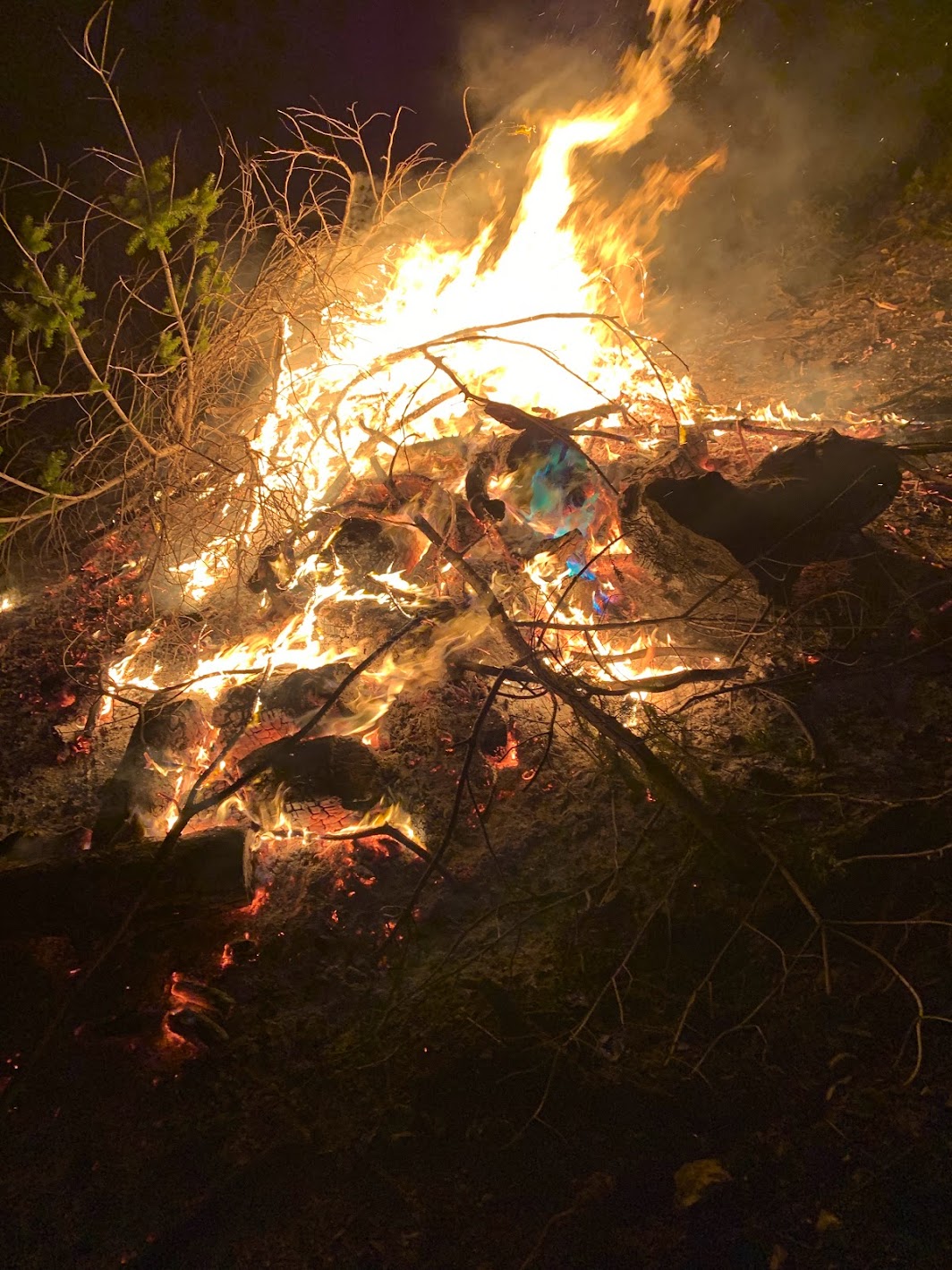
With the rain and cool weather, for many reasons….it is fire time. How do we weigh the balance between the benefits of burning wood for heat and wildland fuel reduction with the drawbacks of indoor and outdoor air pollution and atmospheric carbon additions/global warming? This moment in this season is a good time to enter that reflective space.
A burn pile being tended
Thinking Ahead
February is historically the wettest time of year on California’s central coast. The most rain falls in February, and the days are still short and the air is cool, keeping the environment moist between rainstorms. In just a handful of months, it will be dry and hot and fire weather will return. Anyone with responsibility to manage any vegetation must regularly plan for fire. Fire storms now march right into towns and so the smallest yard keepers have to think about the flammability of their situation. Why wait until the fiery weather is upon us? Cool days make for excellent outdoor working weather, and the wet environment opens up all sorts of opportunities for biomass processing.
Our Cultural Controls on Pile Burning
The native peoples burned dry natural vegetation, and so must we. With the rains and surrounding vegetation so moist, it has been an excellent time to do ‘pile burning.’ The CZU CAL FIRE unit, which oversees Santa Cruz and San Mateo County, started allowing rural residents to burn dry piles of vegetation starting last November 11, but how long that permission will last depends on the weather. CAL FIRE says, “Dry, natural vegetation, grown on the property may be burned outdoors in open piles unless prohibited by local ordinances.” But first you have to apply for a CAL FIRE permit using an online system; and then you can only burn on a day that the Air Resources Board says is okay – when the smoke won’t be too much of a health hazard. You’ll need to do another permit application from them using, again, an online system. Interestingly, while CAL FIRE allowed burns a few weeks earlier, the Air Board burn season is December 1 – April 30.
What About Composting Woody Debris for Fire Safety?
There is an understandable uprising against burning given concerns about climate change. Many people are suggesting composting biomass instead of burning it.
If you are in town, you can meter out your green waste bins by pruning out any dead or overgrown plants, a little at a time …. week by week. If you live out in the countryside and have to deal with a lot of woody biomass, you haul it to the dump or think of other solutions. How the dump manages to dispose of that much composted biomass is a conundrum.
There are permaculture folks and other Hügelkultur practitioners who suggest burying woody material beneath agricultural or horticultural beds, taking advantage of rotting wood for soil carbon benefits including increased water retention. This is a lot of work so it is applicable for only small amounts of woody debris in specific situations. Others suggest burying biomass to reduce erosion in downcutting drainages. My limited experience suggests caution with this approach as any wood that appears out of the soil will probably ignite during wildfire, burning and cooking the soil in the drainage. I share the same experience and caution for Hügelkultur: bury it well and hope it rots fast (you’ll need to keep it moist)!
What About Chipping?
With diesel or gas-guzzling chipping machines, it is questionable whether chipping is any better than burning biomass for atmospheric carbon impacts. There is also a concern about the wood chips catching fire in wildfires. One person I know had a nice pile of chips slowly disappearing into their grassy yard soil until someone built a warming fire on top of them…which ignited a few days later into a large conflagration that was difficult to extinguish. Best to bury chips, too – but not so easy to do! The same cautions apply for the practice of mastication- those big machines that chip vegetation ‘in place.’ Masticated material lying in carpets across the ground are less dangerous, but they still carry wildfire. And so, let’s turn back to the burning option.
Burning in Santa Cruz
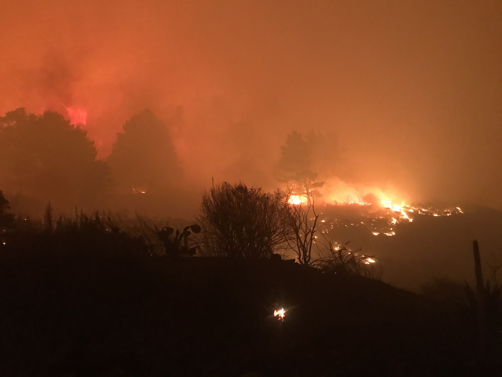
The CZU Lightning Complex Fire burned 85,000 acres….mostly incompletely. That’s the region’s biggest, most obvious UH-OH! If you look at most of that acreage, you will see thousands and thousands of dead trees, which are slowly falling and creating a giant fire hazard. Do you recall the Creek Fire pyrocumulonimbus cloud and extreme fire behavior, including tornadoes of flames? That fire and other fires in the Sierra Nevada were greatly exacerbated by large numbers of trees killed by drought and beetles. We are facing the same danger in the footprint of the CZU Lightning Complex Fire. State Parks and other landowners have been using pile burning to reduce fuels to mitigate such a catastrophe, but a lot more needs to happen: the ‘treated landscape’ is much smaller than the untreated areas at this time. Still, I know of more than 500 burn piles having been ignited this season, so there is hope.
The CZU Lightning Complex Fire – Eating up vegetation a mile a minute on Wednesday August 19, 2020
Another method of burning involves using an ‘air curtain burner’ or a ‘carbonator.’ These both look like large metal shipping containers. Air curtain burners use high powered fans to contain sparks while logs get incinerated. Carbonators use more controlled air exchange so that they create ‘biochar’ – charcoal that can be used in agriculture or horticulture. Vineyards have been experimenting with biochar as a soil amendment that holds some promise for increased soil water retention. Horticulturally, biochar may substitute for carbon- and nature-unfriendly (mined) peat moss. We need to study biochar to see how long it retains carbon in the soil – long- or short term – to understand its potential for helping global warming by sequestering carbon.
Burning Wood: Carbon Neutral?
There is a movement afoot to reduce the use of wood for fuel, but to what end? In the San Lorenzo Valley and elsewhere, folks have long complained about air quality degradation due to badly managed wood heating apparatus. Unfortunately, folks use old wood fueled heaters and/or burn poor quality wood. As with burn piles, folks should be careful to burn only dry wood: there ought to be some rules for firewood sales to disclose percent moisture content in fire wood. Also, firewood needs to be stored so it doesn’t get wet after it is delivered to someone’s home. Wet firewood smokes a lot. Dry firewood burned in a modern woodstove, using smart fire building and maintenance methods can greatly reduce pollution while using a sustainable fuel source. The California Air Resources Board has a great website on cautions about, and helpful tips for, using wood for heating, and as an alternative suggests using electrical heaters.
Two thirds of California’s electricity comes from natural gas – fossil fuel! That figure is more hopeful in our region if you choose to get your power from Central Coast Community Energy, which is shooting for 60% renewable by 2025. Heating with wood is considered by many to be carbon neutral because the carbon that cycles from the atmosphere into plants, and then into wood fuel, isn’t fossil carbon but natural-cycling carbon. Plus, harvesting that woody carbon has the potential around here of being part of the solution to our current, catastrophic wildland fire fuel problem.
I hope you will carefully consider the right way to use wood for heat and take some time to manage fuels and vegetation where you can.
-this article originally posted by Bruce Bratton at his BrattonOnline.com weekly blog- get it automatically by subscription at his website…support local journalism and donate to Bruce- he could use your help!
We live in a very rich area for salamanders and newts. And, when it starts raining, everywhere becomes newt and salamander habitat.
The Menagerie
Right nearby, if you went searching, you could find 8 salamander species: Gabilan and California slender salamanders as well as arboreal, California giant, Santa Cruz black, Santa Cruz long-toed, and tiger salamanders, and then the oddly-named yellow-eyed Ensatina. Add to that our two local newt species – rough skinned and Coast Range newts – and you will realize how much there is to learn about these 10 species.
Where do you find these creatures? Well, that depends….let’s start by thinking about their most vulnerable life history stage, when these creatures are teeny tiny eggs.
Pond Breeding
The newts and some of the salamanders depend on aquatic habitats for breeding, and that’s where they lay their eggs.
Dark, long-lasting, deep shaded ponds are the easiest place to find newts. Interestingly, both the rough skinned and Coast Range newts are found in our area. Some ponds have both species, but other ponds just have one or the other. These newts attach balls of eggs to sticks, roots, and such to make sure that the pre-hatched babies are nurtured in the right depth of water, in the right amount of shade, with the right amount of cover. In the right part of the Monterey Bay, those same egg-laying spots in shady ponds are also coveted by another salamander…the endangered Santa Cruz long-toed salamander, which is found only in southern Santa Cruz and northern Monterey Counties.
Those 2 newt species also can raise babies in warmer, sunny ponds, where another species of salamander is also found. California tiger salamanders love those warm pools, rubbing elbows with western pond turtles, western toads, and California red-legged frogs. These are often grassland ponds managed by ranchers to provide water for cattle. Tiger salamanders like to attach their eggs to pond debris, and you can find their eggs in ponds from southern Santa Cruz County into ponds across Fort Ord and beyond. Our population of California tiger salamanders is protected by the federal government because they have been listed as Threatened under the federal Endangered Species Act.
Spring and Creek Breeding
Those 2 species of amazingly adaptable newts can also raise eggs in stream pools, but streams aren’t the best place for wee newts or salamanders. As you might have seen from this winter, streams get flowing pretty fast, and eggs would soon be headed into the salty sea! So, newts head to streams in the spring as soon as the storms calm down where they raise a summer brood. That spring movement also coincides with the mysterious migration of California giant salamander larvae. The biggest of our local salamanders, the rare California giant salamander probably raises most of its eggs in the muck, under the gravels and among the woody debris of near-stream springs and seeps, safe away from raging floods. Once hatched, the larvae must wriggle and flop downslope into streams. Head upslope, and there are still more odd salamander egg-raising habits.
Eggs Out of Water
A few salamanders raise eggs on what is broadly known as ‘debris,’ but they are probably more picky than we understand. I’ve seen and heard about the rare and only recently described Santa Cruz black salamander tending eggs in gaps on pieces of hard rock…near streams or in moist areas. Those beautiful star-studded sallies are nearly impossible to spot, and there are so few places known that I can’t share a place that you could go to spot them. You are much more likely to encounter arboreal salamanders, maybe even in your neighborhood park if there are native oaks nearby. Those toothy arboreal salamanders place their eggs in moist tree cavities…or ‘in debris.’ Similarly, California (northern Monterey Bay) and Gabilan (central Monterey Bay) slender salamanders place eggs ‘in debris.’ Then there’s the yellow-eyed Ensatina, which I’ve only found in holes and bark of big, rotting moist logs – again ‘debris.’ In case you haven’t gathered – there is a lot to learn about ‘upland’ salamander egg placement and what constitutes nesting ‘debris.’ Share your observations with me on this group, if you’ve seen something interesting!
Groovin’ and Movin’
Their eggs need water or at least moisture-laden debris, but when it is raining newts and salamanders are EVERYWHERE. That’s bad news for them because of the many roads replete with squashing tires of fast-moving vehicles. But, let it rain and adult newts and salamanders take the opportunity to move around, and they sure can move!
In the pouring rain, I’ve encountered California giant salamanders hiking streamside redwood fire roads. In the middle of stormy rainy nights on several occasions, I’ve found arboreal salamanders on my porch. By the second winter of age of a brush pile, slender salamanders have somehow used the cover of drizzly nights to find their way under the stacked branches…hopefully not going to get cooked by a feckless fuel reducing pyromaniac. On those same rainy nights, yellow-eyed Ensatinas stretch their tiny legs to crawl across the forest floor to crawl up and then wedge themselves in just the right rotten bark plate of a 3-year old downed fir.
Meanwhile, the first winter storms see California tiger salamanders hiking along cattle trails in the meadows to find new ground squirrel holes to call home for a while. Because of their rarity, scientists have actually monitored this salamander’s movements…up to 1.2 miles out of ponds and then across the wide-open grasslands! Like tiger salamanders, newts also move far across the uplands. Newts, tiger salamanders, and perhaps Santa Cruz long toed salamanders tend to move in great big groups during the nights of the first biggest rains. Along Carmel Valley Road – and hopefully in more places, soon – you can see signs warning about newt migrations. Migration areas aren’t extensive: they are normally fairly concentrated. Some folks are trying to create underpasses where rare salamanders can safely cross roads…the problem being how to guide them to those narrow culverts or bridges.
They Need Your Help
How can you help our area’s rich newt and salamander diversity? If you live in the country, the first best thing you can do is to not drive at night during the first 3 storms of the winter. You can see the weather forecast…get your groceries early and cancel your evening appointments. Then convince your neighbors and friends to do the same…figure out a way to remember this next rainy season! This past year, the migration was narrowly restricted to the early December storms in our area. Since then, there have been very much fewer newts and salamanders on the roads.
Likewise, watch where you walk in the forest- newts are constantly wandering around dark, moist forest trails all winter.
Oh, and did you catch that need for debris? It seems our inclination to ‘clean up’ debris. Wherever you can keep debris around – logs, sticks, brush – those are newt and salamander habitat. Likewise, for those of you looking to do some fuel reduction, it is best to move the contents of your brush pile, branch by branch, onto a burn pile a few yards away from where it has been stacked for more than a month.
Finally, whenever or however you can…let’s restore more native plants to our landscape- the newts and salamanders all eat bugs and there are more bugs emanating from diverse, native ecosystems.
-This column originally printed by Bruce Bratton in his BrattonOnline.com blog, which contains a wealth of intelligent writing: sign up for a weekly feed!